

A large part of southern Ontario, including the Greater Toronto Area, is expected to get hit with significant snowfall on Wednesday afternoon that will bring anywhere from 15 to 40 cm of snow.

Environment Canada has upgraded its weather alert from a special weather statement to either a snowfall warning or a winter storm warning — stretching from Toronto to Sarnia, to north of Barrie to North Bay, and east to Ottawa.
According to the snowfall alert for Toronto, it is expected that the snow will begin late afternoon with peak snowfall rates of 2 to 4 cm per hour. The total snowfall expected for Toronto is around 15 cm.
However, Global News meteorologist Ross Hull said parts of north and east GTA are expected to get higher amounts, between 15 and 25 cm.
Hull said a Texas low is passing through the Great Lakes and southern Ontario, including the Greater Toronto Area, by Wednesday afternoon. Snow is expected to start falling at around 4 p.m.
Areas towards Ottawa are expected to see up to 40 cm of snow and area in and around Barrie may see between 20 and 30 cm of snow, with a winter storm warning in place in these locations. Snowfall amounts could possibly exceed 5 cm an hour.
However, Hull said there is enough cold air in place by Wednesday afternoon for the system to bring snow, which could be heavy at times and make it difficult for cleanup crews to keep up. He notes this will have a big impact on the Wednesday evening commute for anyone with travel plans on the road or by air.
Ontario’s southern most tip along the Lake Erie shoreline, between Windsor to Niagara Falls and Fort Erie, is under a freezing rain warning due to the changeover, Environment Canada indicated.
“There’s still some uncertainty on warm air that will move in with this system which could bring a change over to mixed precipitation for areas close to the Lake Ontario and Erie shorelines (including downtown Toronto) later tonight,” Hull said. “That would reduce snowfall amounts for those areas but bring the potential for freezing rain, ice pellets, or rain.”
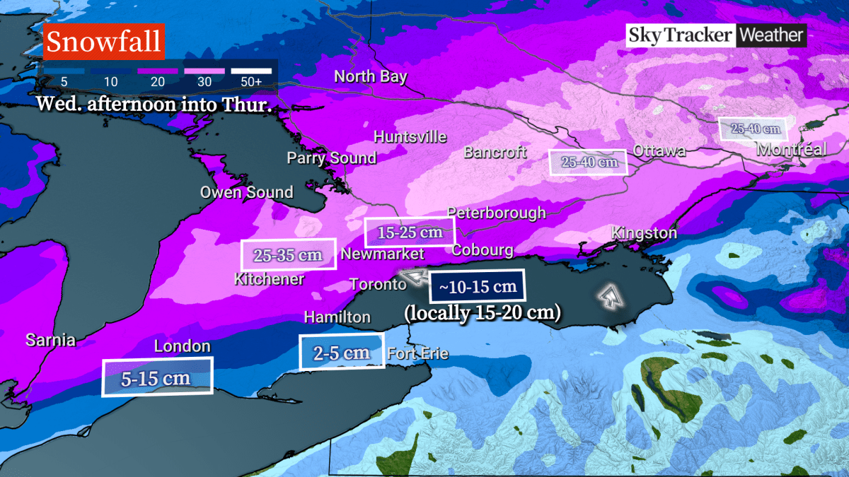
The snow is expected to taper off by Thursday morning as it heads east across Quebec and the Maritimes.
Hull added there will be reduced visibility at times as winds pick up blowing the freshly fallen snow.

Get breaking National news
“Consider postponing non-essential travel until conditions improve,” Environment Canada said in its weather alert. “There may be a significant impact on rush hour traffic in urban areas.”
This next round of snow comes days after Toronto and parts of southern Ontario got dumped with of up to 20 cm of snow in some areas on Saturday night into Sunday.
As well, Hull said models are showing another potential winter storm emerging from the U.S. this upcoming weekend, which could bring more heavy snow to the area on Saturday into Sunday — making it three storms in one week for southern Ontario.
Parking prohibition: City of Toronto declares ‘major snow storm condition’
The City of Toronto’s transportation services says it is declaring a “major snow storm condition” as of 10 p.m. Wednesday — Barbara Gray, the general manager, said it is one of the tools that the city can use to assist with operations in order to clear streets as efficiently as possible.
- Old Man Winter wallops B.C.’s Mainland/Southwest region, major highway closed
- Calgary hit by unexpected blast of spring snow, causing dozens of crashes
- False spring strikes again: Saskatchewan prepares for incoming winter weather
- Albertans’ interest in alternative forms of travel growing as fuel prices spike


The condition temporarily prohibits parking on all designated snow routes. This prevents vehicles from being buried underneath snow piles left behind by plows and allows for emergency services to respond quickly, Gray said.
Anyone who is parked on snow routes could be fined or towed, the city said.
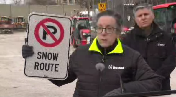
Vincent Sferrazza, director for transportation services, said multiple rounds of plowing and salting will be activated as “we will be getting quite a considerable amount of snow.”
Sferrazza added after the cleanup, the city will be transitioning to “snow removal.” He said this does not happen often.
“When you get such a significant amount of snow, and also the temperatures will be cold, you will not have that melting benefit. It will stick around. So as a result, we will have to transition to removal of snow and that will likely happen early next week, probably around Monday.”
It’s expected the condition will remain in place until Tuesday.
Meanwhile, the TTC said it is cancelling a pre-planned early subway closure on Line 1 to reallocate resources for the incoming storm.

Comments
Want to discuss? Please read our Commenting Policy first.