Temperatures have dropped and snow is possible later this week in southern Ontario as more typical winter weather returns to the region.

It follows record-high temperatures that were experienced in southern Ontario on Friday.
“Temperatures have certainly settled back to more typical February values, although the start of this week will still feature high temperatures above freezing, with temperatures dipping below the freezing mark through the overnights,” Global News meteorologist Ross Hull said.
The average daytime high for Toronto in early-to-mid February is -2C.
“We have been nowhere near that this month,” Hull said.
“That will start to change this week as we see temperatures during the day and overnight drop closer to normal.”

Get breaking National news
Some wintry precipitation is also possible this week.
On Tuesday, there’s a chance of some wet flurries or showers, but there won’t be any — or very minimal — accumulation.
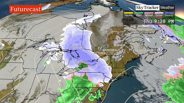
“It’s a system that moves in Thursday that we are watching more closely,” Hull said, noting it brings with it the first chance of accumulating snow for southern Ontario, including the Greater Toronto Area, in weeks.
- Infrastructure Ontario can’t say if science centre roof was damaged in major snowstorm
- Man escapes Toronto jail by impersonating inmate set for release: Toronto police
- Ontario man charged in elderly woman’s death evaded police for months before alleged murder
- Toronto snowstorm highlights accessibility issues, disability advocates say
“Temperatures will still be around freezing during the day, but as the bulk of the precipitation moves in during the evening, there is the potential for it to accumulate as temperatures drop.”
Five to 10 cm of snow is possible for the Greater Toronto-Hamilton Area.
North of Toronto and towards cottage country, some areas could see 10 to 20 cm, Hull said.
“We are still a few days out and there’s still some uncertainty on exact amounts, but if you have travel plans Thursday evening into early Friday morning, take note and keep an eye on the forecast,” Hull said.
“It will certainly be an adjustment for drivers considering the lack of measurable snow this month.”


Comments