

A conference organized by Toronto Chief Planner Jennifer Keesmaat unveiled a striking statistic, online magazine Yonge Street reported last week: 60 per cent of people living in eight so-called tower neighbourhoods in the inner suburbs don’t have drivers’ licenses.

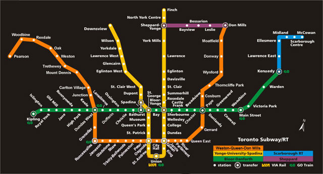
We requested driver’s licence data by postal code from the province’s transportation ministry a while back for another project. It was easy enough to repurpose it for this map, with an overlay showing the subway and Scarborough Rapid Transit.
There are people with driver’s licences who don’t regularly drive or own cars and people who own cars who don’t use them to commute, but it’s a safe bet that people without driver’s licences don’t have access to a car, for the most part, unless someone else drives them to work on a regular basis.
As the map shows, many of them don’t have access to high-quality transit, either.
(“A tremendous number of them walk,” Chief Planner Jennifer Keesmaat told her conference audience, “even when walking conditions aren’t that good.”)
Three areas stand out as having very few residents with driver’s licences while being far from any rapid transit line:
- A long area of the west end stretching south from Jane and Finch to Black Creek and Eglinton.
- Pedestrian in life-threatening condition after being hit by vehicle in Mississauga
- Judge at trial of man accused of killing cop was concerned over Crown changing theory
- Ontario transportation minister pitches 24-hour work to speed up Gardiner construction
- ‘Love at first sight’: Snow leopard at Toronto Zoo pregnant for 1st time
- Thorncliffe Park (Flemingdon Park would probably pop out of the map differently if its postal code wasn’t shared with Don Mills and parts of the Bridle Path).
- A chunk of mid-Scarborough stretching north and east from Scarborough Golf Club Road and Eglinton.
The map does reinforce the case for some version of the Downtown Relief Line (one possible map is here) with arms stretching far north – the east one up Don Mills to Sheppard, the west one up Black Creek to Rexdale. It also shows (once again) that “Downtown Relief Line” was an unfortunate label from the start – the relief being offered is mostly to the suburbs.
The planners went on to talk about making it safer and easier to walk in a suburban landscape designed for cars (more here).
(In 2011, a Global News investigation showed that Toronto’s 100 most dangerous intersections, measured as a ratio of pedestrian accidents to pedestrian traffic, were largely in the suburbs: 78 were in Etobicoke, North York or Scarborough.)

Would future transit lines serve non-drivers better than what we have now? Back in October, Global’s Leslie Young looked at the tangle of projects, plans and possibilities for the future of Toronto’s transit. Some are just a gleam in a planner’s eye, and some, like the Eglinton LRT, have tunneling machines grinding away as you read.
So how to they serve the light areas on the map? Well, some better than others. As Torontoist’s Hamutal Dotan pointed out yesterday, the Finch LRT does this very well, as does the Eglinton Crosstown LRT, especially west of Bathurst. (The map doesn’t make it all that clear, but the eastern spur of the-extension-that-shouldn’t-be-called-the-DRL also does, serving high-density Flemingdon Park and Thorncliffe Park.)
The missing component would be an east-west LRT at about Wilson, or alternatively a western (DRL) spur heading north from Dundas West station at least as far as Finch.
Comments