

Hurricane Lee has begun transitioning to a post-tropical storm as it makes its way toward Canada’s East Coast — but one meteorologist warns it’s still expected to pack a punch.

Bob Robichaud, warning preparedness meteorologist with Environment Canada, said as Lee approaches the coastline, it should be “very close to hurricane strength.”
“A lot of people have a misconception that a post-tropical storm is somehow a lesser storm,” he told reporters during a news conference Friday afternoon.
Robichaud said the post-tropical designation means the structure of the storm will be different, but it “says nothing about the intensity.”
“It will still be a large storm, very near hurricane strength at the time,” he said. “Whether it’s tropical or post-tropical prior to arriving here, the designation is not really important right now.”
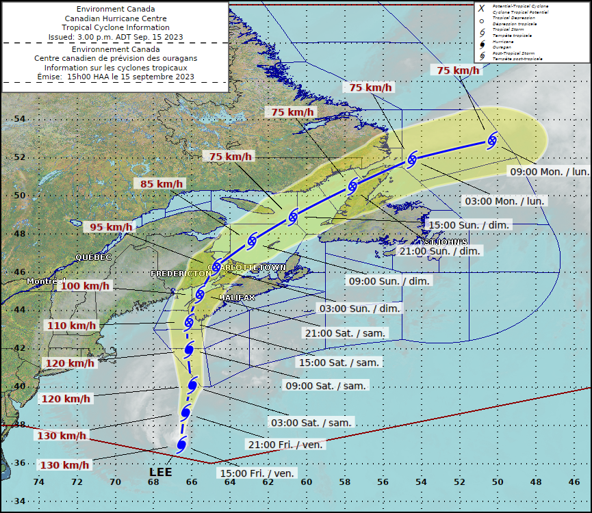
As of 3 p.m. Friday, the storm was about 749 kilometres south of Yarmouth, N.S., moving north at 35 km/h, with maximum sustained winds of about 130 km/h.
The centre of the storm is expected to land in southwestern Nova Scotia Saturday afternoon, but Robichaud said the impacts will be felt in the Yarmouth area “way before that.”
“So the time to prepare certainly is today,” he said. “Tomorrow will be too late.”
As well, due to the large size of the storm, Lee’s impacts will be felt “a great distance beyond where the centre actually tracks,” Robichaud said.
Rain, wind and storm surge will be seen throughout the region into Saturday night, with gusty winds lingering in some areas well into Sunday as Lee makes its way toward Newfoundland.
Robichaud said the worst of the conditions will last for about 12 hours, but for “many areas” the gusty winds will last more than 24 hours, even up to 36.

Get daily National news
“This is going to be kind of a prolonged event,” he said.
Weather warnings issued
Environment Canada has issued numerous weather warnings across Nova Scotia and New Brunswick.
A tropical storm warning is in effect for New Brunswick’s Fundy Coast, as well as most of mainland Nova Scotia except the northern part of the province.
Hurricane watches remain in effect for Grand Manan and Coastal Charlotte County in New Brunswick, and Digby, Yarmouth, Shelburne, and Queens Counties in Nova Scotia. The watch was extended to Lunenburg County and Halifax County Friday morning.
“There is a possibility that Hurricane Lee could bring near-hurricane conditions,” Environment Canada warned in its weather alert.
The storm is set to bring heavy rain, wind and storm surge to the Maritime provinces. Rainfall warnings have been issued for most of New Brunswick except for the northwestern areas, and for portions of western mainland Nova Scotia.
It’s possible that rainfall totals could exceed 100 millimetres, especially in areas near and to the left of Lee’s track — from western Nova Scotia northward through central and northeastern New Brunswick.
Wind warnings are also in effect for most of mainland Nova Scotia as well as the Fundy Coast of New Brunswick. Areas under the hurricane watch could see wind with gusts up to 120 km/h, while those under the tropical storm warning could see sustained winds of 70 km/h gusting to 90 to 100 km/h.
“Given the abundance of rainfall over the past several months, and most recently Thursday, the ground is quite saturated and will be more prone to uprooted trees, especially those that are in full foliage,” the Canadian Hurricane Centre warned in a Friday afternoon update.
“Widespread power outages appear likely across most of mainland Nova Scotia and near the Fundy Coast of New Brunswick.”
Environment Canada also said high waves and water levels will be “widespread” due to Lee’s large size, with the most impacted areas expected to cover much of the Atlantic Coast of mainland Nova Scotia — where there could be breaking waves of four to six metres in areas facing the open ocean.
“Elevated water levels (storm surge) combined with waves will result in coastal flooding during the high tide late morning to noon Saturday from Shelburne County to Guysborough County then again during the high tide late Saturday evening,” it said.


“Water levels up to 1.5 metre (5 feet) above high tide is possible.”
There could also be high waves “to a much lesser extent,” along the Fundy coast of New Brunswick.
Weaker than Fiona
During the news conference, Robichaud said Lee is not expected to cause the same level of damage and destruction as post-tropical storm Fiona did last year.
While Lee is very large in size, Robichaud said the intensity of the storm is already weaker than Fiona was when Fiona made landfall.
“Although we will see impacts, the impacts won’t be as severe as what we saw with Fiona,” he said.
Lee is the 12th named storm of the Atlantic hurricane season, which runs from June 1 to Nov. 30 and peaked on Sunday.
The National Ocean and Atmospheric Administration in August forecast between 14 and 21 named storms this season. Six to 11 of them are expected to become hurricanes, and of those, two to five might develop into major hurricanes.
‘Be ready,’ officials urge
Southwestern Nova Scotia and southern New Brunswick are among the areas expected to be hardest hit from the storm, and officials from both provinces are urging people to be prepared.
People are advised to clear their yards of debris, secure doors and windows, clear rain gutters and downspouts, fill up on gas, charge electronics, and prepare an emergency kit with enough food and water to last at least 72 hours in case of prolonged power outages.
“While the storm may be weakening, it is still a significant storm, so we need to be ready,” John Lohr, Nova Scotia’s minister responsible for the Emergency Management Office, said during a news conference.
“I want to take this opportunity to remind Nova Scotians that if they haven’t already done so, the time to prepare is now – before the storm reaches our shores.”
He said it’s “particularly important” for those living in southwestern Nova Scotia and along the Fundy shore to take precautions.

New Brunswick Public Safety Minister Kris Austin also urged caution, telling reporters Friday afternoon that it’s important to not “underestimate what this could be.”
“Just look back to the recent history of the storms that we have had here in New Brunswick, and the impact they’ve had on all of our lives,” he said.
“Dorian, Fiona, and even even a few years back with Arthur, I know people were without power up to two weeks and even longer. So be ready.”
Further information about storm preparedness can be found on the Nova Scotia and New Brunswick websites.

Comments
Want to discuss? Please read our Commenting Policy first.