
SASKATOON – Saskatonians had a bit of a rude awakening on Sunday and Monday morning with the first two snowfalls of the season.

The first few flakes flew around 2 a.m. Sunday morning, much of which melted upon contact with the ground.
However, many residents found themselves scraping half-melted snow off their windshields as temperatures remained below freezing for the first few hours of the day.
Light snow was once again reported at the Saskatoon airport from 3 a.m. to 6 a.m. on Monday morning.
This gave a light dusting onto grass and some cooler surfaces, which lasted a little longer into the day.
If you’re feeling frustrated about the early snowfall, it may be of some comfort to know that the flurries started flying almost two weeks earlier last year.
The first recorded snowfall of 2012 was on Oct. 10.

Get daily National news
Although last year was a bit of an anomaly.
In October, Saskatoon typically sees above freeing ground temperatures that are usually too warm for any significant accumulations of snow to occur.
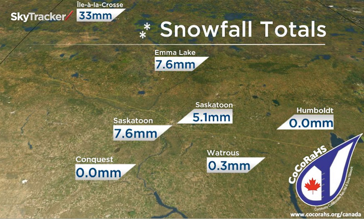
The Community Collaborative Rain Hail and Snow network (CoCoRaHS) is a new initiative aimed at offering better precipitation information for meteorologists, climatologists, flood forecasters, farmers and the general public.
Volunteer CoCoRaHS observers are trained to measure precipitation across the province.
They recorded the snowfall totals seen in the photo featured above from Sunday morning to Monday at 7 a.m.
CoCoRaHS Saskatchewan is always looking to train new volunteer observers to help improve weather documentation, forecasting and analysis across the region.
After every significant rain and snowfall event, Global Saskatoon will bring you the latest precipitation totals provided by CoCoRaHS on the Evening News at 6 p.m. and News Hour Final at 10 p.m.
Want your weather on the go? Download Global News’ Skytracker weather apps for iPhone, iPad and Android.


Comments
Want to discuss? Please read our Commenting Policy first.