Environment Canada warns prolonged rains will drench parts of northern B.C. over the weekend, raising the potential for localized flooding.

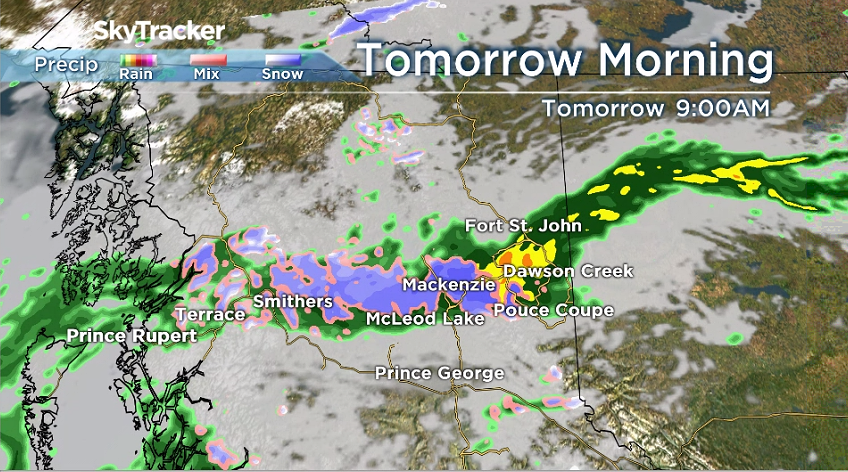
A rainfall warning has been issued for the North and South Peace River regions as the weather office says rainfall of up to 50 millimetres is expected between Friday and late Saturday.
According to Global News senior meteorologist Kristi Gordon, regions near the Rockies are expecting the highest rainfall amounts — between 60 to 80 millimetres. There’s a chance Tumbler Ridge may not see any rain, while Dawson Creek, Chetwynd and Hudson’s Hope are pummelled, she added.
The downpour will ease to a few showers on Saturday night.
Read more: Why has B.C.’s spring been so cold and wet?
Environment Canada’s warning says heavy rainfall on top of pre-existing saturated soils can make the situation worse and raise the risk of localized flooding.

Get breaking National news
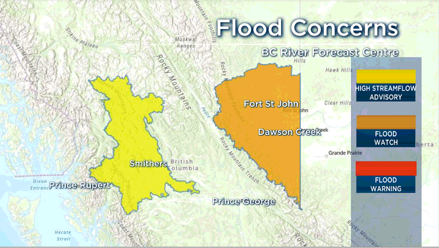
The River Forecast Centre has upgraded a high streamflow advisory to a flood watch for the Peace Region, advising that waterways could reach levels only experienced once a decade as rain combines with ongoing snowmelt.
“This is setting up to be a dangerous rain event because it is going to be very heavy over a very localized region,” said Gordon. “It’s almost like a fire hose shooting from Alberta west across the Peace River region to the coast.”
- Old Man Winter wallops B.C.’s Mainland/Southwest region, major highway closed
- Calgary hit by unexpected blast of spring snow, causing dozens of crashes
- False spring strikes again: Saskatchewan prepares for incoming winter weather
- Albertans’ interest in alternative forms of travel growing as fuel prices spike
Gordon advised the entire region to be prepared because it’s difficult to predict “exactly where this fire hose will aim.” In a statement on Friday afternoon, Emergency Management BC did the same.
“We are urging the public to stay clear of the fast-flowing rivers and potentially unstable riverbanks and to be ready to evacuate should there be flooding,” it said.
“If you are placed under an evacuation order, leave the area immediately and do not return home until you have been advised that the evacuation order has been rescinded.”
The province said it has 3.2 million sandbags, 15 kilometres of Gabion baskets and nearly 30 kilometres of Tiger Dams at the ready. It has already deployed some “flood control assets” to communities across B.C., it added.
Emergency Management BC advised people under a flood watch to prepare a grab and go bag that includes several days of clothing, toiletries and medications, and copies of important documents.
Conditions are expected to peak by Sunday according to the River Forecast Centre, which is maintaining a high streamflow advisory for the Bulkley River and its tributaries in northwestern B.C., as rain and snowmelt push those waterways to two- to five-year flows before their expected peak.
— With files from Kristi Gordon and The Canadian Press


Comments
Want to discuss? Please read our Commenting Policy first.