
A new long-term transportation study focusing on the east end of Peterborough recommends a number of infrastructure projects over the next three decades to address a projected increase in traffic and residential growth.

The “Eastside Transportation Study,” launched in 2020, will go to city council on Monday for approval. The study addresses expected growth in East City and the Liftlock Secondary Plan area thanks to several new developments. The city’s Official Plan projects the east end by 2051 will have an additional 7,500 people and 2,000 more jobs, therefore, creating an increased travel demand and a need for an “enhanced transportation system.”
“This growth is consistent with the substantial growth forecast to occur throughout the rest of the city,” the report states.
Among recommendations in the study — found in an executive summary here — includes:
Bridges:
- Extending Maria Street west with a new bridge over the Otonabee River that would connect to Sherbrooke Street downtown at Water Street.
- Upgrade McFarlane Street, between Ashburnham Drive and Armour Road, including a new modern two-lane bridge across the Trent-Severn Waterway to help alleviate vehicle traffic that travels through the tunnel of the historic Peterborough Lift Lock on Ashburnham.
- Widening of the Parkhill Road bridge across the Otonabee River and the addition of turning lanes at intersections
Intersection upgrades:
- Armour Road at Parkhill Road — including new turning lanes
- Armour Road at Maria Street — signalization
- Ashburnham Drive at Lansdowne Street — widening and upgraded trail crossing
- Television Road at Parkhill Road — new signals or roundabout
- Television Road at Old Norwood Road — turning lanes and new signals
- Television Road at Paul Rexe Boulevard — new signals

Roadway upgrades:

Get breaking National news
- Upgrades to Maniece Avenue, Old Norwood Road and Parkhill Road East (between Leahy’s Lane and Television Road)
- Ashburnham Drive realignment/reconstruction, between Maniece Avenue and Trent View Road, including shifting the road to a location east of the current alignment
Roadway widening or new roads:
- Television Road widening to four or five lanes, between Highway 7/Lansdowne Street and Parkhill Road
- Parkhill Road widening to four or five lanes, between Water Street and Leahy’s Lane
- Ashburnham Drive widening to four or five lanes, between Lansdowne Street and Maria Street
- Sherbrooke Street – Maria Street connection and extension, between Water Street and Television Road – the potential widening of Maria Street to four lanes and the Maria Street bridge across the Trent Severn-Waterway to four lanes, and the potential extension of Maria Street east to Television Road as a two-lane arterial road.
- County Road 4 widening / new alignment — dependent on approval from Peterborough County which owns the road.
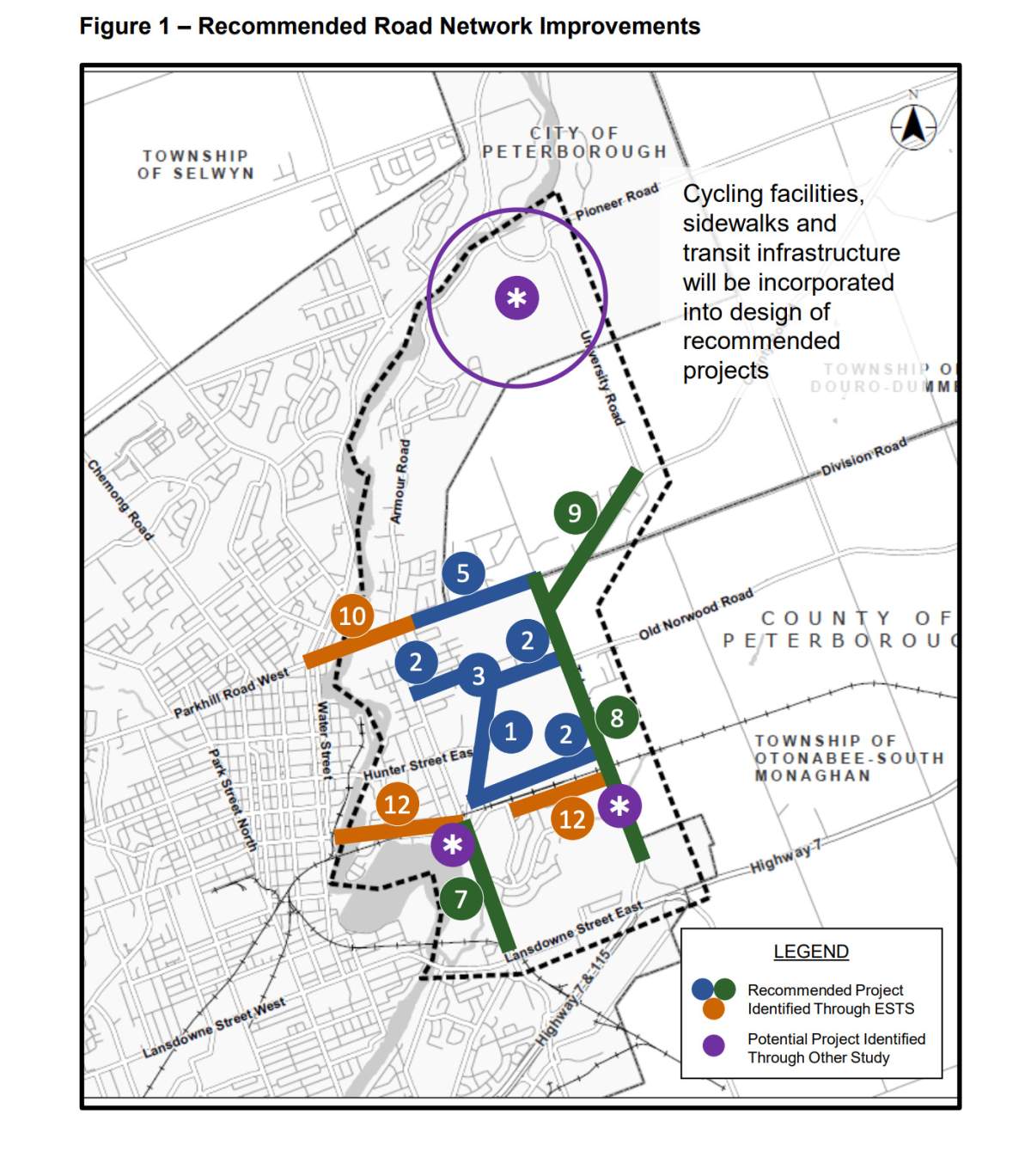
The city estimates the costs of the recommended road network improvements would be $209 million.
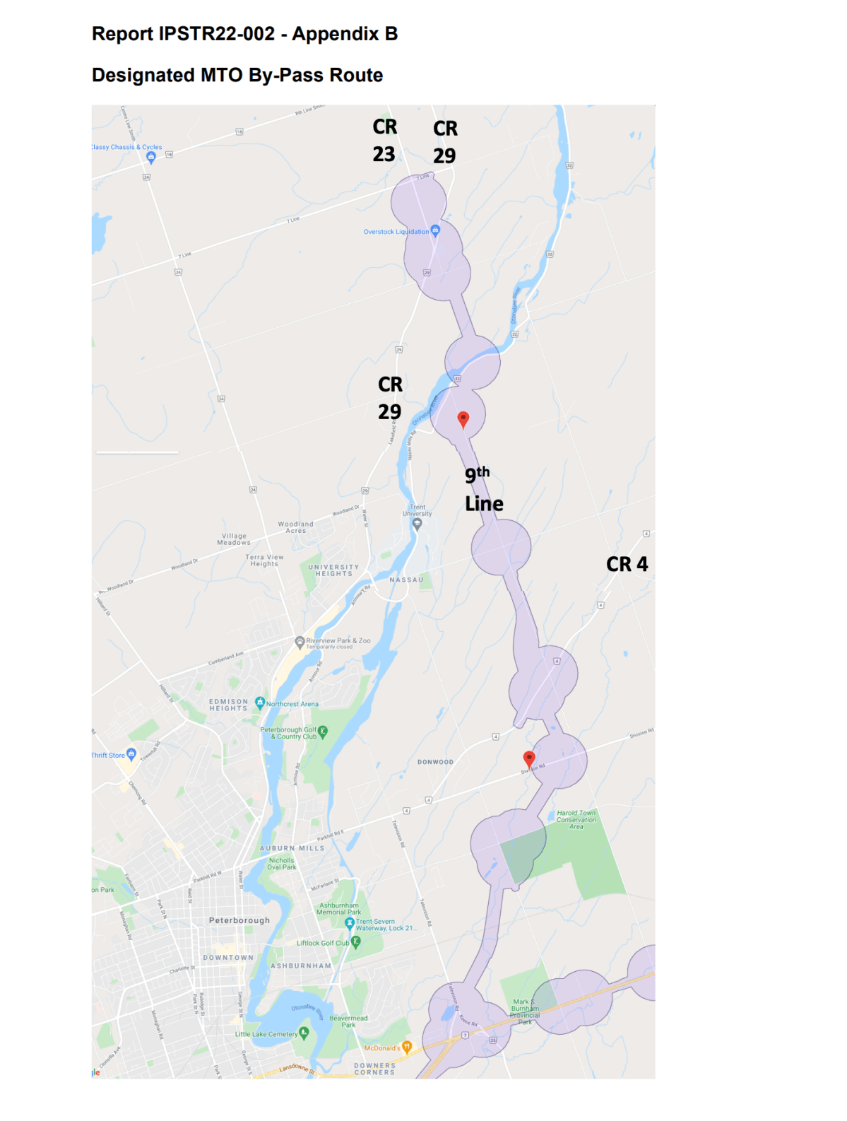
Bypass


The report also recommends city council inquire with the province about the so-called “Peterborough East Bypass” — a corridor set aside in the 1970s for a future provincial highway.
The report says the bypass would run northeast from the Hwy. 115/Hwy. 7 intersection with Television Road and Lansdowne Street, following Douro-Dummer 9th Line and crossing the Otonabee River to connect with former Highway 28/Highway 507, which are now known as County Road 29 and County Road 23, just south of the village of Lakefield.
A section of the bypass would impact planned lots for the new Cleantech Commons research park at Trent University, the study notes, therefore, the study recommends city council inquire about having the corridor connect to nearby Highway 28 instead.
“The north end of the corridor no longer connects to a provincial highway, and the current corridor designation limits development opportunities, most notably in the vicinity of Trent University,” the report notes.
In an email from the Ministry of Transportation, Dakota Brasier, senior communications advisor and press secretary for Minister Caroline Mulroney, notes that while the corridor wasn’t referenced in the “Connecting the GGH: a Transportation Plan for the Greater Golden Horseshoe,” released this week, the document will be reviewed and updated on a regular basis for future transportation needs.
“Though some projects aren’t part of ‘Connecting the GGH: a Transportation Plan for the Greater Golden Horseshoe, they could be considered for further analysis in the longer term,” said Brasier. “The MTO will retain the corridor designation for lands under the Peterborough East Bypass link, which would reserve the land required to build this corridor, and will continue to assess the need based on evidence received.”


Comments
Want to discuss? Please read our Commenting Policy first.