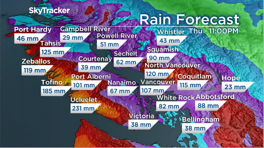
An atmospheric river consisting of two systems with heavy rain is developing and set to hit the South Coast.

Global News meteorologist Kristi Gordon said the river will hit Tuesday through early Thursday but the most significant rain will fall on Wednesday.
She said the intensity of rain during this time will be greater.

“The good news is that is only a two-day event, not like the multiple-day event we had in November.”
The current forecast for total rainfall from late Tuesday through early Thursday is between 80 and 120 millimetres for Metro Vancouver, with the majority along the North Shore mountains, Gordon said.
The Fraser Valley can expect between 50 to 100 millimetres and Vancouver Island between 50 and 200 millimetres with the majority along the west coast, Gordon added.

As a comparison, Gordon said the November storms brought 200 to 300 millimetres to the Fraser Valley in two days.
Abbotsford Mayor Henry Braun said they are “as prepared as they can be” for the storm.

Get daily National news
Speaking on Global News Morning, Braun said the city is still under a local state of emergency and they raised the Sumas Dike half a metre than what it was before the November storms hit.
“Most of the sandbags are still in place,” he said. “I am concerned about Clayburn Creek and historic Clayburn Village.”
Braun said residents in those areas should be prepared for potentially more flooding this week.
He added the city did put in requests to remove sediment from the second and third rivers in the area before Christmas but those requests still have not been approved by the provincial government.
We can’t just walk into creeks and start bailing sand and gravel without approval, Braun said, adding he will be calling Deputy Premier Mike Farnworth on Tuesday to ask about those approvals.
The city still has 16 landslides they are monitoring and Braun said they will be keeping a close eye on the Nooksack River in Washington State.

Gordon said rain will not be the only issue with these storms.
The freezing level is expected to rise and snowmelt will add to the runoff.
On Tuesday it could rise to between 1,500 to 2,000 metres and on Wednesday up to 2,500 metres.
Gordon said the November storms drove the freezing levels to more than 3,000 metres and the good news is a January snowpack is less vulnerable to rainfall because it has consolidated.

Avalanche Canada has also issued a warning about a high risk of avalanches Tuesday and Wednesday for the South Coast and the Sea to Sky mountains.
The organization said heavy rain and wind will create dangerous avalanche conditions. Wait out this storm as travel in avalanche terrain is not recommended.


Comments
Want to discuss? Please read our Commenting Policy first.