


British Columbia’s south coast could find itself facing new risks of flooding this week, as a series of rainstorms approaches with the potential to rapidly melt weeks of accumulated snow.

“We are tracking a series of systems that will bring a significant amount of rainfall in the coming days,” Global BC meteorologist Yvonne Schalle said.
“Freezing levels will rise to close to 2,000 metres on the South Coast. Periods of heavy rain combined with high freezing levels may potentially lead to localized flooding.”
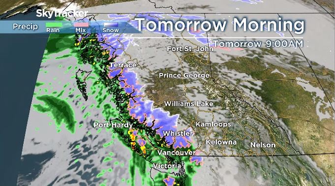
The first system is forecast to arrive Monday, and Schalle said the region could see between 80 and 100 millimetres of rain by Thursday.
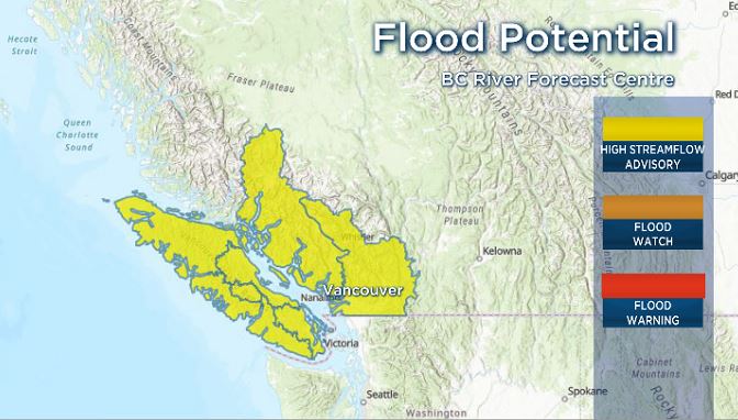
The BC River Forecast Centre issued high streamflow advisories for the South Coast and Vancouver Island Sunday afternoon.
Forecast centre hydrologist Johnathan Boyd described the combination of heavy rain with the significant amount of snow already on the ground as a “concerning situation.”

“You’ve had an extended period of several weeks of of cold temperatures combined with a low elevation snowpack developing, and we are ripe and ready to melt that with rising temperatures and then potentially heavy rainfall for Tuesday and Wednesday periods,” he said.

Get daily National news
Boyd said it was too early to say where exactly the heaviest rains and the greatest risk would be felt, but that so far the “bulls eye” was trending towards central Vancouver Island and the Sunshine Coast.


The good news, he said, is that temperatures were forecast in the 9 to 10 C range, much cooler than the atmospheric rivers that devastated southern B.C. in November.
Because of that, the precipitation is expected to fall as snow at higher elevations, meaning only lower-elevation snow is expected to melt.
Boyd said the primary concern remains the potential rapid rise of creeks and rivers in low- to mid-elevation watersheds, though he noted areas that were affected by November’s floods could see problems as well.
“Just the base flow could still be fairly high, and of course the erosion that did occur at that period of time may lead those systems to be a bit more vulnerable to high flows again,” he said.
Boyd said people should exercise extreme care around the potentially unstable banks of creeks and rivers, and ensure that storm drains are clear of snow, ice and debris to help with drainage.
Residents are also urged to closely monitor Environment Canada for weather statements or warnings in the days to come.
Comments
Want to discuss? Please read our Commenting Policy first.