

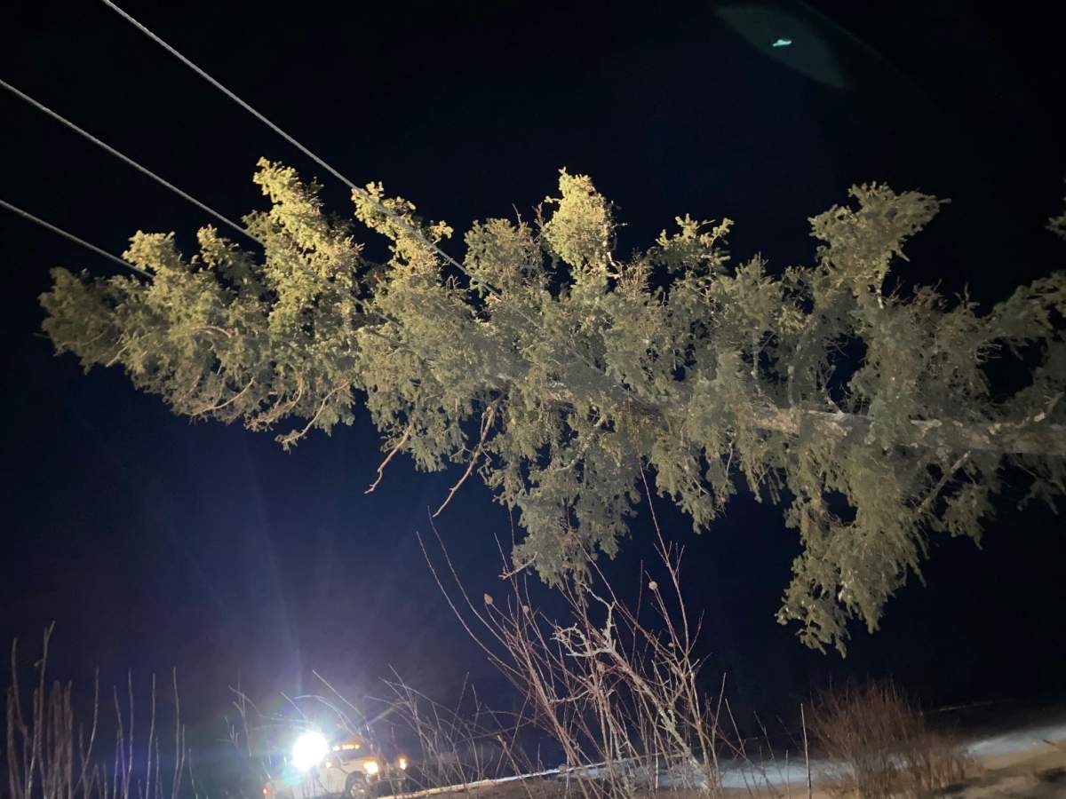
Southern Saskatchewan was hit hard by an Alberta clipper overnight Wednesday, with a blizzard leaving provincial highways an icy mess.

A new provincial peak wind gust record was set for January.
The peak gust of 143 km/h was recorded in Bratts Lake, south of Regina. Environment Canada said if it was rated on the enhanced Fujita scale for rating tornadoes, it would have been an EF-1.
Regina also set a January peak wind gust record for the city at 126 km/h.
Several other communities had peak wind gusts of at least 120 km/h: Yellowgrass (133 km/h), Elbow (122 km/h), Mankota and Estevan (both 120 km/h).
Winds topped out at just over 100 km/h in Saskatoon.
At the height of the blizzard, the Highway Hotline reported highways closed in the Regina, Moose Jaw, Swift Current, Kindersley and Rosetown areas.
Travel was not recommended on several other highways. The latest highway conditions can be found at the Highway Hotline.
Saskatchewan RCMP spokesperson Rob King said roughly 173 vehicles were reported abandoned or posing traffic hazards.
More than 180 multi-vehicle collisions were reported to RCMP over a 24-hour period and King said that number is likely higher, as not all collisions may have been reported to police.
Power outages
SaskPower said it’s working on restoring power to communities around the province, but said it is asking for patience as crews continue to deal with blustery conditions.
SaskPower CEO and president Mike Marsh said he understands outages are frustrating for some customers.
“Nothing is more important than the safety of our customers and our employees,” Marsh said Thursday in a statement.
“We are doing everything we can to get the lights back on as quickly as possible without jeopardizing the safety of our crews.”
SaskPower said it is prioritizing restoring power to essential services first before focusing on restoring power to customers.

Get breaking National news
SaskTel said it is experiencing service outages in a number of communities, while others have limited service.
Officials with the Crown corporation said there is no estimated time to have service restored.
They added services in more communities may fail as backup batteries deplete in areas where there are power outages. Crews are working to connect generators to network sites and high-priority wireless sites.
Read more: Wind gusts reached 137 km/h in province on Wednesday thanks to Alberta clipper low-pressure system
Winds topped out at just over 100 km/h in Saskatoon, with multiple power outages were reported in the city.
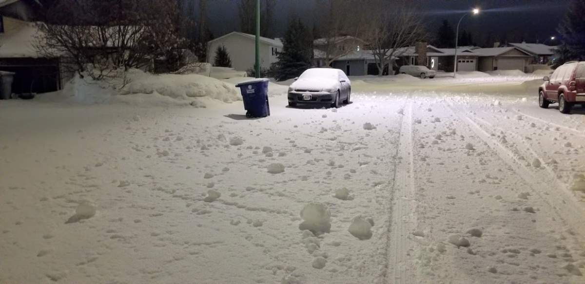
Ghost snowballs and ‘sailboggans’?
Many Saskatchewan residents spotted snowballs that appeared to roll themselves — because they did.
Environment Canada meteorologist Terri Lang said the ghost snowballs are called snow rollers.
“We don’t see them often,” Lang said. “They’re a really cool phenomenon.”
Exact weather conditions are required for them to form.
“The winds have to be really, really strong with this really, really sticky snow,” she said. “When the wind is blowing that hard, it gets the ball rolling… and you get a whole series of these rollers.”


Regina resident Ryan Doka tried to make the most of the extreme conditions by inventing and testing the “sailboggan.”
The feat of engineering excellence involved a toboggan, garbage bags and some PVC pipes. The garbage bags caught the wild winds and Doka set sail.
“I’m a man who enjoys a little bit of adventure, so once the winds started picking up, I knew that I had to make something crazy,” he said.
“I really thought I wasn’t even going to take off at first and then the moment I stepped on, I shot off like a rocket.”
Prior to the low-pressure system sweeping across the province a number of daily high record for Jan. 13 were set:
- Broadview: 5.7 C (old record 5.0 C in 1943)
- Buffalo Narrows: 0.2 C (old record 0.0 C in 1964)
- Elbow: 7.2 C (old record 4.0 in 1989)
- Estevan: 6.7 C (old record 6.2 C in 1987)
- Last Mountain Lake: 5.2 C (old record 4.0 C in 1989)
- Outlook: 7.1 C (old record 5.6 C in 1942)
- Regina: 6.2 C (old record 4.6 C in 1980)
- Saskatoon: 6.4 C (old record 6.1 C in 1942)
- Swift Current: 7.3 C (old record 6.7 C in 1894)
- Uranium City: -3.1 C (old record -5.9 C in 1981)
- Watrous: 5.0 C (old record 3.5 C in 1986)
- Weyburn: 7.8 C (old record 5.0 C in 1983)
- Wynyard: 6.0 C (old record 5.0 C in 1987)
- Yorkton: 5.3 C (old record 4.4 C in 1943)
A winter storm warning remains in place for the Hudson Bay region as the system moves into Manitoba.
Environment Canada said overnight freezing rain has now changed over to snow, with two to four centimetres expected before it tapers off Thursday night.
-With files from Anna McMillan
Comments
Want to discuss? Please read our Commenting Policy first.