

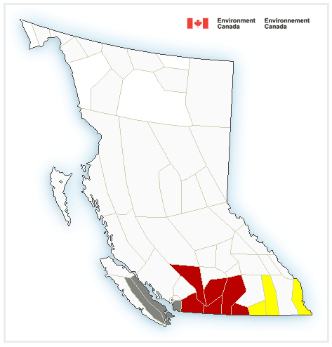
Environment Canada is warning about a “hazardous” winter storm expected to pummel B.C.’ Southern Interior highway mountain passes on Monday and bring snow to the valley bottoms.

The winter storm warning covers the Okanagan, Similkameen, Boundary, Fraser Canyon, Nicola and West Kootenay regions of the B.C. Interior, as well as the Fraser Valley portions of the Coquihalla and Highway 3.
“A deepening Pacific low will make its way across Washington state on Monday,” the agency said in the weather warning, issued Sunday morning.
“Abundant moisture associated with the system combined with cold air to the north of its trajectory will produce heavy snowfall across the southern interior of British Columbia.”
Snow will begin early Monday morning and intensify rapidly, in the range of 25 to 35 centimetres, Environment Canada said.
Expect hazardous driving conditions on the Okanagan Connector, from Merritt to Kelowna, the Coquihalla Highway, from Hope to Merritt, Highway 3, from Hope to Princeton via Allison Pass, as well as the Paulson Summit to Kootenay Pass stretch along Highway 3.
Weather officials are urging commuters to postpone non-essential travel until conditions improve.

Get breaking National news
Public Safety Canada also encourages everyone to make an emergency plan and get an emergency kit with drinking water, food, medicine, a first-aid kit, and a flashlight.
A snowfall warning is in effect for the Okanagan, stretching from Vernon to Penticton, with up to 20 centimetres of snow expected to fall in the valley bottoms.
“Surfaces such as highways, roads, walkways and parking lots may become difficult to navigate due to accumulating snow,” the weather agency said.


In Metro Vancouver, a special weather statement has been issued for Vancouver, Burnaby, New West, the North Shore, Coquitlam, Maple Ridge, Surrey, Langley, Richmond and Delta, with “heavy, wet snow” possible at higher elevations.
“Areas with the heaviest precipitation will see the heavy rain switch over to heavy wet snow above about 150 metres during the day,” Environment Canada says.
“Mixed rain and snow is even possible at sea level.”
On Vancouver Island, the snowfall warning is also in effect for Greater Victoria, Duncan to Nanaimo, Nanoose Bay to Fanny Bay and the Malahat Highway from Goldstream to Mill Bay.
Public weather alerts for British Columbia can be found here.
Vehicle accidents and road conditions can be monitored on DriveBC here.
Comments
Want to discuss? Please read our Commenting Policy first.