

Severe thunderstorm watches and warnings were issued across central and eastern Alberta on Tuesday afternoon, and Environment Canada said the storms were capable of producing strong wind gusts, large hail and heavy rain.

By late Tuesday night, all weather warnings, watches and advisories in Alberta had been lifted.
In the early afternoon, thunderstorm watches were in effect from the edge of Edmonton south to the U.S. border, and from the middle of the province to the Saskatchewan border.
Several were upgraded to warnings as the afternoon went on, before being downgraded back to watches and dropped around the supper hour.
Several funnel cloud advisories were also issued north and east of Calgary, as well as in central Alberta surrounding Red Deer.
Funnel cloud weather advisory north of Calgary, near Red Deer
Shortly after 4 p.m., Environment Canada said conditions were favourable for the development of funnel clouds north of Calgary, and about an hour later several people began posting photos of what appeared to be funnel clouds near Carstairs.
North of Calgary, the weather advisory was issued for Carstairs, Stirlingville, Cremona, Water Valley, Olds, Didsbury and Sundre in Mountain View County and for Airdrie, Cochrane, Crossfield, Bottrel and Madden in Rocky View County.
Shortly after 5 p.m., funnel cloud advisories were also issued for the areas in and around Drumheller, Three Hills, Brooks, Strathmore and Vulcan to the north and east of Calgary.
The funnel cloud advisories were expanded an hour later to include much of central Alberta around Red Deer, including Lacombe, Camrose, Stettler, Ponoka, Maskwacis and the surrounding rural areas.
These types of funnel clouds are generated by weak rotation under rapidly growing clouds or weak thunderstorms, Environment Canada said, adding the weak rotation is normally not a danger near the ground.

Get breaking National news
The weather agency added there was a chance the rotation could intensify and become a weak landspout tornado. It said those kinds of tornadoes do not usually cause significant damage but can still be dangerous. They can be strong enough to topple trees, damage roofs or toss debris short distances.
Shortly after 8 p.m., the province issued an emergency alert for Newell County in southeastern Alberta because of a possible tornado. A few minutes later, a new alert was issued saying “the tornado has dissipated.”
Shortly after, a new emergency alert was issued for the county that said a rotating severe thunderstorm that is “possibly producing a tornado” was spotted about five kilometres west of Tilley at 8:45 p.m. The storm was moving east at 30 km/h and Tilley was reported to be in its path, according to the alert.
Shortly after 9 p.m., a new emergency alert was issued indicating the storm had weakened and that the tornado alert had ended.

Severe thunderstorms
A series of watches and warnings were issued for a large swath of central Alberta throughout Tuesday afternoon.


The first warning was issued just before 2 p.m. for Cypress County in the southeastern corner of the province, where meteorologists were tracking a severe thunderstorm capable of producing very strong wind gusts, up to toonie size hail and heavy rain.
The weather agency said the storm developed 30 kilometres southeast of Onefour and moved northeast towards the Saskatchewan border at 45 to 55 km/h.
Between 3 and 4 p.m., Environment Canada upgraded other thunderstorm watches to warnings in central Alberta.
The warning was mainly in effect for Flagstaff County; however the following areas were also included in the warning: Red Deer, Ponoka, Innisfail, Stettler, Lloydminster, Wainwright, Vermilion, Provost, Camrose, Wetaskiwin and Tofield.
The weather agency said a line of severe thunderstorms stretching more than 100 kilometres between Daysland and Wainwright had developed and was moving north at 30 km/h. The storms were capable of producing very strong wind gusts, up to nickel size hail and heavy rain, Environment Canada said.
A severe thunderstorm warning was also issued at 6 p.m. for the Red Deer area, including Sylvan Lake. Environment Canada said meteorologists were tracking a severe thunderstorm capable of producing pea to dime size hail and heavy rain.
The nearly stationary storm was expected to bring heavy rain to areas near the city of Red Deer and the weather agency said rainfall rates near 50 mm/h could be expected. The warning was dropped about 30 minutes later.
All of the warnings and watches ended by 6:30 p.m.
Tuesday’s thunderstorm outlook
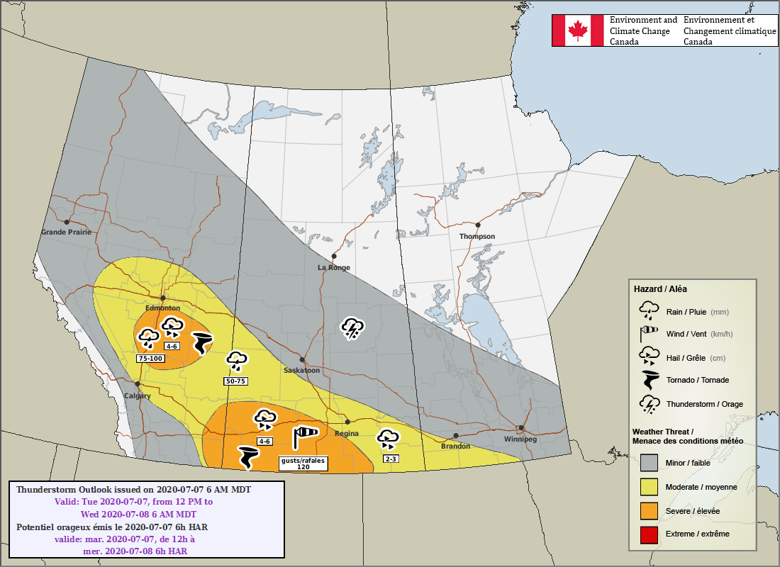
The Environment Canada thunderstorm outlook for Tuesday afternoon and evening said there was a risk of tornadoes, two to six centimetre (golf to tennis ball size) hail, wind gusts up to 120 km/h, and heavy rainfall of up to 75-100 mm in central and southeastern Alberta.
The weather agency’s outlook said a trough line — an area of low pressure in which storms can form — would organize and trigger severe thunderstorms.
Conditions in the southeast part of the province were “favourable for supercell development with a risk of tornadic development.”
Central Alberta was expected to see pulse storms — single-cell thunderstorms of substantial intensity that produce severe weather for short periods of time.
“Following the storms of Tuesday afternoon, the low moving up from Montana is likely to bring significant rainfall through Tuesday night into Wednesday,” Global Edmonton weather specialist Phil Darlington said.
“Amounts of 20 mm or more are possible in the Edmonton area.”
Environment Canada said severe thunderstorm watches are issued when atmospheric conditions are favourable for the development of thunderstorms that could produce one or more of the following: large hail, damaging winds, torrential rainfall.
If safe to do so, share your weather photos with us via the Global Edmonton Facebook and Twitter accounts. You can also post updates from your community using the hashtags #yegwx and #abstorm.
Want your weather on the go? Download Global News’ Skytracker weather app for iPhone, iPad and Android.

Comments
Want to discuss? Please read our Commenting Policy first.