

UPDATE: The extreme cold warning mentioned in this story has ended

A large swath of Saskatchewan, including Saskatoon and Prince Albert, is under an extreme cold warning Friday morning.
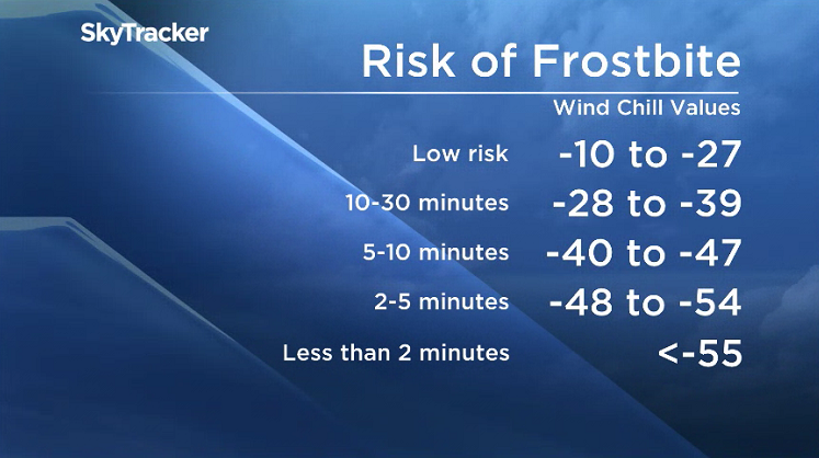
Environment Canada said wind chill values of -40 to -45 are expected in southern and central regions as air temperatures near -30 C combine with wind speeds of 10 to 15 km/h.
Some moderation is expected later in the day as cloud cover increases and a ridge of high pressures moves off to the southeast.
In the north, an arctic air mass has settled over the northern Prairies.
A prolonged period of extreme wind chills ranging from -45 to -50 continues Friday, with some moderation expected in a few areas before extreme cold conditions return overnight.

Get daily National news
Temperatures are expected to warm slightly after the weekend.
Frostbite can occur in less than 10 minutes at these values.
Anyone heading outside should dress warmly and in layers and ensure the outer layer is wind resistant. Anyone working outside should take regular breaks to warm up.
Emergency supplies, such as extra blankets and jumper cables should be kept in vehicles.


Environment Canada issues extreme cold warnings when there is an elevated risk to health such as frostbite or hypothermia.
WATCH BELOW: With an extreme cold warning in effect for Saskatoon, gas and energy consumption across the province is on the rise. Cami Kepke reports.

For the latest conditions and warnings, download the SkyTracker weather app.


Comments