

First snow of the season headed to Saskatchewan this week.

Saskatoon forecast
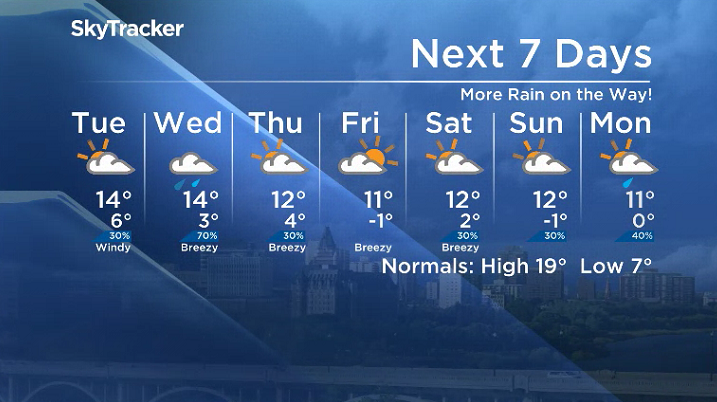
Monday
It was a cool start to the week with temperatures dipping back to 1 C Monday morning in the city with some fog patches early in the day.
After a few showers rolled through mid-morning, the mercury was able to recover up toward double digits heading into the noon hour.
Mostly cloudy skies linger into the afternoon with a chance of showers and risk of a thunderstorm as we make it up to a daytime high in the mid-teens.

Get daily National news
Monday night
Rain is likely at times Monday night with the risk of a thunderstorm with a low pressure system swinging in from Alberta as we cool back into mid-single digits overnight under mostly cloudy skies.
Tuesday
By the time you wake up Tuesday morning, the system will have already passed and the associated cold front will be sweeping through central Saskatchewan.
Mostly cloudy skies with a slight chance of showers will remain in the wake of the system with breezy northwesterly winds gusting up to 40 km/h as we struggle to get to an afternoon high in the mid-teens.

Wednesday-Friday
The next system passing by to the south brings in another round of rain on Wednesday with an afternoon high in the mid-teens.
Mostly cloudy skies with a chance of showers linger into Thursday before skies clear and sunshine starts the day on Friday before yet another round of clouds rolls in with daytime highs dropping into low double digits both days.


Meantime, parts of northern Saskatchewan will be getting hit with snow beginning early Wednesday and continuing into Thursday along a cold front.
The cool air sliding in from the north is likely to change liquid precipitation to solid form in the Key Lake, Buffalo Narrows and La Ronge areas on Wednesday with the chance some could spread as far south as the Lloydminster area by early Thursday.

Special weather statements are in effect in parts of Alberta for snow moving into that province as well this week.
Weekend outlook
There is a chance of some rain early Saturday ahead of some afternoon clearing before the next system builds in some clouds on Sunday with afternoon highs in low double digits both days.
Rachel Vidak took the Sept. 10 Your Saskatchewan photo at Saint Gregor:

Saskatoon weather outlook is your source for Saskatoon’s most accurate forecast and is your one stop shop for all things weather for central and northern Saskatchewan with comprehensive, in depth analysis that you can only find here.
For weather on the go download the Global News SkyTracker Weather App for iPhone, iPad or Android.
Comments
Want to discuss? Please read our Commenting Policy first.