

Numerous communities in the Boundary region of B.C., east of the Okanagan and west of the Kootenays, were placed on evacuation alert Wednesday night, with 66 people already forced from their homes due to record-setting flood levels.

The latest alert area impacts about 1,550 people.
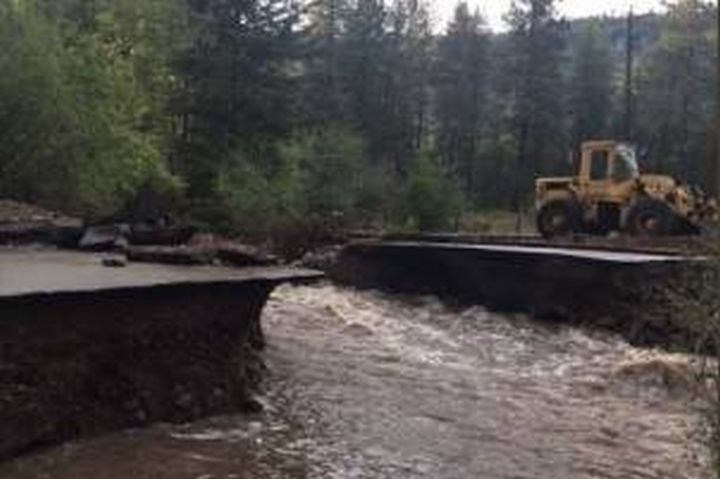
Rivers in the Boundary are expected to reach their highest levels since 1948, according to the Regional District Kootenay Boundary.
“Virtually all properties in the West Kettle River, Kettle River, Granby River, Christina Creek and Christina Lake floodplain within the Boundary region are now on evacuation alert,” a release from the RKDB late Wednesday night said.
An evacuation order was undertaken earlier in the evening around Grand Forks, sending 58 people to the Emergency Reception Centre at the Grand Forks Curling Centre on 21 Street.
“A floodplain-wide evacuation alert is in place because water levels in creeks, rivers and lakes are expected to peak at record high levels the next 24 to 36 hours,” the release said.
In Brown Creek, 56 people have lost road access, but are safe and are said to be sheltering in place.
“As water levels peak, high water could cut off road access to many properties in the floodplain, even if individual homes may not be directly threatened by flooding,” the RKDB said. “Without overland access, emergency responders will be unable to reach residents and residents will be unable to reach emergency services. Lack of access and egress is a threat to life and safety.”


The evacuation alert means being ready to leave on short-notice if flood conditions worsen.
“During an evacuation alert, residents need to gather essential items, move important belongings to higher locations in their homes, arrange to move pets or livestock, arrange for alternate accommodation for themselves and designate a meeting place for family or others away from the evacuation area.”
The City of Greenwood and properties next to the Boundary Creek watershed are not included in the evacuation alert.
The alert and evacuation information, including details on addresses within Johnston’s Flats, Almond Gardens, Darcy and Manly Meadows, can be viewed at the regional district website.
- ‘It’s nice to be the villain’: Vancouver Canucks gear up for Game 3 in Nashville
- Joffre Lakes to close for 3 periods this year under agreement with First Nations
- ‘Why aren’t we doing more?’ White Rock on edge with killer on the loose
- B.C. carjacking victim says she doesn’t trust the ‘catch-and-release’ system
Comments