

Winter returns with heavy snow hitting Saskatoon before arctic air dives back in.

Snowfall Warning
Environment Canada has ended the snowfall warning for Saskatoon, but it remains in place for the Prince Albert, North Battleford, Lloydminster and Meadow Lake areas for 10 to 20 centimetres of snow expected by Saturday.
The low pressure trough that’s been spreading snow into the region will swing back through southern Saskatchewan on Friday night and Saturday morning with a few more centimetres accompanying it.
For the latest weather alerts download the Global News SkyTracker Weather App for iPhone, iPad or Android.
Motorists planning to head out on roads are advised to use caution and check in with Saskatchewan Highway Hotline before heading out.
Saskatoon Forecast
Friday
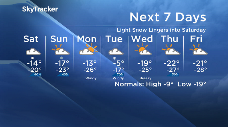
Ten centimetres of snow fell in the city overnight as low pressure system and coupled fronts blasted the region with light snow continuing into the morning as temperatures slid back to -14.
-20 wind chills also returned to the region during the morning with the mercury rising up to -13 by midday as snow kept falling and making road conditions slippery.
Two to four centimetres of snow is expected to hit the city Friday afternoon with reduced visibility and slippery road conditions sticking around as we rise up a few more degrees to around -11 for an afternoon high.

Get daily National news
Friday Night
Snow will pick back up Friday night as an upper level front lingering behind the system swings through and brings in an additional two to four centimetres of fluffy snow as we cool back into the mid-minus teens.

Saturday
- Thorhild, Westlock counties declare state of agricultural disasters due to rain
- ‘Prolonged stretch of hot air,’ poor air quality advisories blanket the Prairies
- 2 tornadoes touched down in Rocky Mountain House, Environment Canada confirms
- Heavy Nova Scotia rain threatens flooding on anniversary of deadly 2023 flash flood


Some of that snow may linger into early Saturday morning before moving out by midday and leaving us under some lingering cloud for the rest of the day.

-25 is around what it’ll feel like with wind chill to start the day with temperatures sitting in the mid-minus teens through the day before cooling back into the -20s by evening.
Sunday
Another wave of moisture will push through on Sunday and keep us under mostly cloudy skies with a slight chance of light snow during the day.
The -20s is where the mercury will sit in the morning before rising up into the minus teens for a daytime high with clouds clearing out in the evening as an arctic high drops in.
Work Week Outlook
Clear skies Monday morning will allow temperatures to drop right back into the mid -20s with wind chills into the -30s before clouds roll back in during the day and we warm into the mid-minus teens.
Snow is expected Tuesday as a system slides in and helps warm us up into mid-minus single digits with windy conditions during the day before arctic air dives us back into -20 daytime highs later behind the system later in the week with morning wind chills approaching extreme warning criteria of -40.
The Your Saskatchewan photo for Jan. 26 was taken in Saskatoon by Dale Evjen.

Saskatoon weather outlook is your source for Saskatoon’s most accurate forecast and is your one stop shop for all things weather for central and northern Saskatchewan with comprehensive, in depth analysis that you can only find here.
Comments
Want to discuss? Please read our Commenting Policy first.