

UPDATE: All warnings and advisories mentioned in this story have ended

Blizzard, snowfall and winter storm warnings remain in place for most of eastern Saskatchewan and central parts of the province are under a blowing snow advisory.
Environment Canada officials said an intense low pressure system currently near Lake Winnipeg continues to bring snow and strong winds to Saskatchewan.
Blizzard Warning
A blizzard warning is in place for Regina, Estevan, Yorkton, Kamsack, Humboldt and the surrounding areas.
Snow, combined with winds gusting to between 80 and 90 km/h, will reduce visibility to 400 near zero at times.
Blizzard conditions will continue throughout Tuesday before improving overnight and into Wednesday morning when the winds diminish.
Road closures are possible and outdoor activity is not recommended.
Snowfall Warning
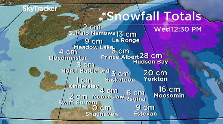
Regions under a snowfall warning could get up to 20 centimetres of snow as the system moves through the province.
Strong northerly winds will generate blowing snow, which could make travel difficult at times.
Conditions are expected to improve Tuesday evening.

Get breaking National news
Snowfall Warning
Regions under a snowfall warning could get up to 20 centimetres of snow as the system moves through the province.
Strong northerly winds will generate blowing snow, which could make travel difficult at times.
Conditions are expected to improve Tuesday evening.
- TransLink bus crash in North Vancouver sends driver, passenger to hospital
- Worker struck by vehicle overnight while fixing roads north of Toronto
- Flood watches, warnings remain in place as cleanup takes place across Alberta
- Video captures unattended boat slamming into dock, other vessels north of Peterborough, Ont.


Winter Storm Warning
Parts of northeast Saskatchewan are under a winter storm warning, with hazardous conditions expected.
The intense low pressure system is expected to bring 30 to 40 centimetres of snow by mid-Tuesday morning before the heavy snow tapers off.
Rapidly accumulating snow may make travel difficult in some locations.
Blowing Snow Advisory
Strong northwesterly winds with gusts up to 80 km/h are expected to develop Tuesday afternoon in areas under the advisory, including Saskatoon, Prince Albert and the surrounding regions.
The wind combined with the fresh snow will produce widespread blowing snow, with visibility reduced to 800 metres or less.
Conditions are expected to improve Tuesday night as the winds diminish.
Latest Conditions
For weather on the go download the Global News Skytracker weather app for iPhone, iPad or Android.
The Saskatchewan Highway Hotline has the latest road conditions.
For flight delays and cancellations, check the Saskatoon International Airport or Regina International Airport websites.
Blizzard Warning
- Regina
- Carlyle – Oxbow – Carnduff – Bienfait – Stoughton
- Estevan – Weyburn – Radville – Milestone
- Fort Qu’Appelle – Indian Head – Lumsden – Pilot Butte
- Humboldt – Wynyard – Wadena – Lanigan – Foam Lake
- Kamsack – Canora – Preeceville
- Moosomin – Grenfell – Kipling – Wawota
- Yorkton – Melville – Esterhazy
Snowfall Warning
- La Ronge – Prince Albert Nat. Park – Narrow Hills Prov. Park
- Melfort – Tisdale – Nipawin – Carrot River
- Pelican Narrows – Cumberland House – Creighton
- Southend – Brabant Lake – Kinoosao
Winter Storm Warning
- Hudson Bay – Porcupine Plain
Blowing Snow Advisory
- Saskatoon
- Martensville – Warman – Rosthern – Delisle – Wakaw
- Moose Jaw – Pense – Central Butte – Craik
- Outlook – Watrous – Hanley – Imperial – Dinsmore
- Prince Albert – Shellbrook – Spiritwood – Duck Lake
Comments
Want to discuss? Please read our Commenting Policy first.