

First positive temperatures of 2017 in Saskatoon today with record breaking heat on the way!

Saskatoon Forecast
Today
-12 was the lowest wind chill value reported early this morning with temperatures down to -5 to start.
High cloud moved back in early in the day, giving mostly cloudy skies right into the middle of the day that’s expected to stick around into the afternoon.
The mercury climbed up above freezing for the first time in 2017 by 11 a.m. with areas south of the city like Outlook seeing temperatures as warm as +5 this morning thanks to strong winds mixing down the heat.
This afternoon, we’re expecting to see thermometers continue to climb with a daytime high around 3 degrees.
Tonight
The cloud cover over the area is expected to stick around through the evening before clearing a bit overnight as temperatures fall back a few degrees below freezing.
Wednesday
-8 is around what it’ll feel like with wind chill Wednesday morning when you head out the door.
We’re expecting to see some sunshine in the morning before clouds build back in during the day.
A southerly breeze will help mix down even warmer air that’s aloft, helping top temperatures out around 5 degrees in the afternoon.
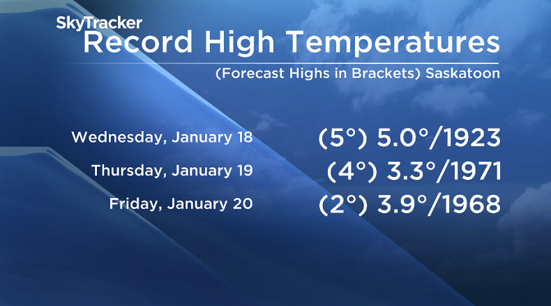
If we exceed 5.0 degrees, we’ll break a high temperature record from 1923, which would make it the warmest January 18 ever recorded in Saskatoon!
Thursday-Friday
Thursday may be the warmest Jan. 19 ever recorded in Saskatoon if the mercury rises above 3.3 degrees, which is the previous high temperature record set back in 1971.
Mostly cloudy skies are likely to linger on Thursday with temperatures expected to top out around 4 degrees, which would make for another history making day!
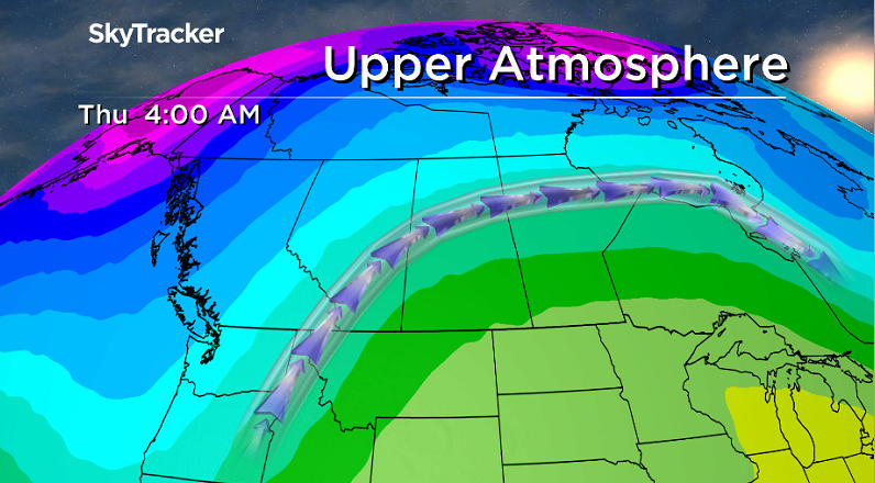


The upper ridge of high pressure over our area that’s been helping keep us warm will hang on for the rest of the week and assist us in the warming.
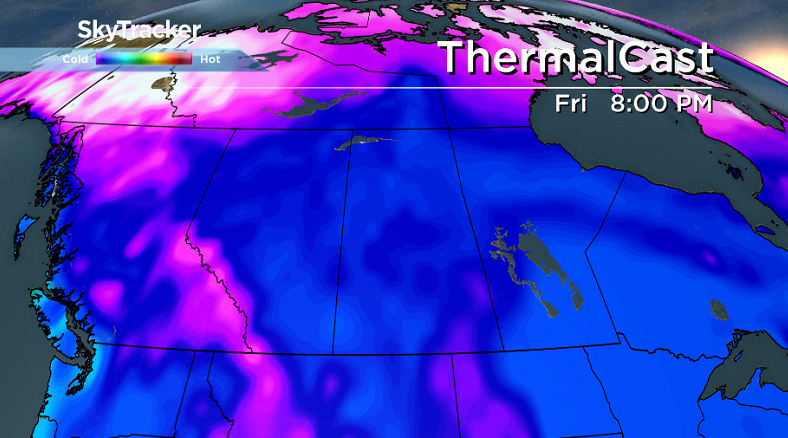
A bit more sunshine is possible on Friday, but temperatures look like they’ll max out a little cooler with an afternoon high just a few degrees above freezing and just short of the record high of 3.9 from 1968.
Weekend Outlook
Cooler air looks like it’ll slip in this weekend, knocking afternoon highs back below freezing.
A trough is expected to back into the area, keeping us in the clouds with a chance of snow, particularly late Saturday into Sunday.
This Your Saskatchewan photo was taken at Jackfish Lake by Gloria Katsiris:

READ MORE: Get a 2017 Your Saskatchewan calendar today
Saskatoon weather outlook is your source for Saskatoon’s most accurate forecast and is your one stop shop for all things weather for central and northern Saskatchewan with comprehensive, in depth analysis that you can only find here.
Comments