

A weather advisory for funnel clouds was issued ffor Saskatoon, Prince Albert and across central Saskatchewan Wednesday by Environment Canada.

This was the second day in a row a funnel cloud advisory was issued in Saskatoon with an unstable air mass in place leading to showers and thunderstorms.

Get breaking National news
READ MORE: Funnel clouds spotted around Saskatchewan Tuesday
These types of funnel clouds are generated by weak rotation under rapidly growing clouds or weak thunderstorms that is normally not a danger near the ground.
READ MORE: What to do when a tornado touches down in Saskatchewan
Environment Canada says there is a chance that this rotation could intensify and become a weak landspout tornado, but if conditions become more favourable for the development of landspout tornadoes, watches and warnings will be issued.
For weather on the go download the Global News Skytracker weather app for iPhone, iPad or Android.
Saskatoon Forecast
Today
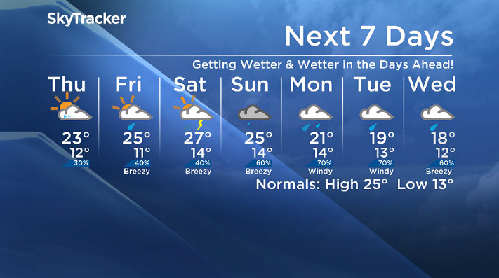
Another active day of weather in the Saskatoon area as an upper disturbance and surface feature move through and generate ideal dynamics favourable for funnel cloud development.
The day started out much calmer and overall pretty nice, starting out at 11 degrees at 5 a.m. as our morning low, but warming up nicely into the mid-teens under partly cloudy skies by mid-morning.
A few light rainshowers moved through late in the morning and over the noon hour, keeping temperatures in the teens through the middle of the day.
We should eventually climb into the low 20s for an afternoon high later on with mostly cloudy skies and a chance of showers and thunderstorms right through the remainder of the day.
Tonight
This evening that chance of showers and thunderstorms will eventually diminish, however most of the cloud cover looks like it’ll stick around as an upper low centred just north of the area keeps us unsettled.
Mostly cloudy conditions will likely keep us a bit warmer with an overnight low expected to be around 12 degrees with some fog patches potentially developing overnight into the early morning hours.
Thursday
Tomorrow looks like it’ll start off with a slight chance of showers under mostly cloudy skies, but those will start to clear out of the area as an upper ridge starts to build in aloft giving us some sunshine in the afternoon.
That solar radiation later in the day will help us hit a high around 23 degrees.
Friday
It does look like we may catch a few sunny breaks early Friday morning before we see a return of the clouds during the day as the next low pressure system moves into Alberta and pushes in the clouds with a chance of showers late in the day into the evening.
It will be our warmest day of the week with temperatures shooting up into the mid-20s in the afternoon.
Weekend Outlook
As the upper ridge starts to break down this weekend, we get an ideal setup for once again, you guessed it – severe weather.
It looks like we’ll see mostly cloudy skies both Saturday and Sunday with a chance of showers and potentially severe thunderstorms across the board.
Daytime highs also look like they’ll stay quite warm, in the 25 to 27 degree range with sufficient moisture and atmospheric dynamics to fire off some strong storms.
A bit of a washout is on the way early next week with rain, potentially heavy at times, expected until the middle of the work week as an upper low swings through.
This Your Saskatchewan photo of a sunset near Thode was taken by Tammy Ollenberg:

Saskatoon weather outlook is your one stop shop for all things weather for Saskatoon, central and northern Saskatchewan with a comprehensive, detailed look at your local forecast that you can only find here.


Comments
Want to discuss? Please read our Commenting Policy first.