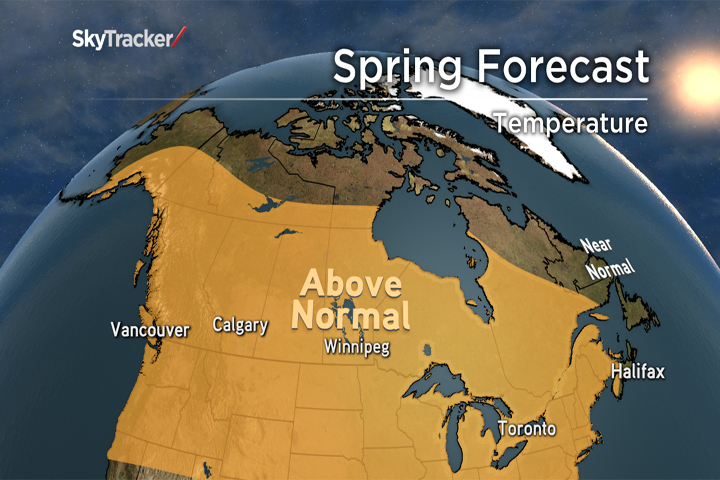
Canada just experienced one of the warmest and least snowy winters on record, which can — at least partially — be blamed on El Niño. Looking ahead to spring 2016, the warmer-than-normal trend will continue from coast to coast with few exceptions.

READ MORE: Do the El Nino rains signal an end to historic drought in California?
El Niño is a warming of the water around of the equator in the Pacific Ocean. This winter, El Niño reached “super” status and became one of the strongest on record, which altered the jet stream around the globe.
El Niño, along with continued effects from climate change and other factors, lead to 2015 being the warmest year on record for our planet. In Canada, the displaced jet stream kept most of the frigid air bottled up over the Arctic and allowed mild Pacific air to flood the weather pattern throughout the winter season.
El Niño is now weakening rapidly and La Niña (a cooling of the water in the Pacific) could develop as early as next winter. But don’t expect to feel an immediate influence: global circulations take time to adjust to changing ocean temperatures, and this lag means our spring will continue to have an El Niño influence.
Spring Forecast: Region by Region
British Columbia and Alberta
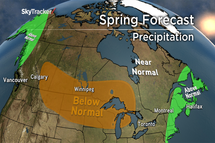
It has been a very mild end to winter across the these two provinces, and this trend will continue through early spring with an eventual trend towards more seasonal temperatures as the overall jet stream weakens and becomes more zonal. This will also lead to increased precipitation for the B.C. coast up through the mountains.
On the other side of the Rockies, Alberta will continue to experience below-seasonal precipitation which is good news for spring flooding concerns.
The Prairies

Get daily National news
Winter 2015–2016 was nothing like the past two in Saskatchewan and Manitoba, and that is good news for residents living near rivers and streams. The limited snow pack will quickly melt this spring and the frost level isn’t nearly as deep into the ground as in past years, meaning spring rainfall will have an easier time being absorbed rather than running off into rivers.
Temperatures here will continue to be average to above seasonal, but watch out for an April surprise or two as winter tries to fight back.
Ontario and Quebec
Much like the rest of Canada, winter was a no-show this year. One storm at the beginning of March brought 10-25 cm of snow to Toronto, Montreal and Ottawa, but much of that has already melted. Even with the colder start to the month, March could end up as one of the warmest on record.
Rain will be heavy through mid-month before a drier pattern sets up later in April and May. Above-seasonal temperatures will be aided by the lack of Great Lakes ice-cover, which normally acts to refrigerate the surrounding areas through the spring. Much like the Prairies, don’t expect winter to fade away without making one last comeback in either late March or early April.
Atlantic Canada and Newfoundland
In this region, the weather has been a roller-coaster ride this winter, with extreme cold and snow followed by extreme warmth. During the mild stretches, some golf courses were able to open in Nova Scotia.
The active weather will continue through March and April where Nor’easters could bring more significant snow and rain. Much like the winter, temperatures will average slightly above seasonal with wild swings from day to day.
Summer Preview
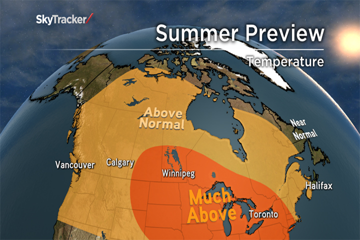
Summer is still several months away, but at first glance it’s looking mild for much of Canada. The biggest deviations above seasonal are likely to be found around the Great Lakes with cooler weather on both coasts.
Rainfall patterns will need to be watched, but drier-than-normal weather is most likely from Manitoba through the Great Lakes. Eastern Canada should be on the lookout for a more active hurricane season than the past couple years.
The Big Picture
After a record warm 2015, 2016 could be another record-setter for temperatures globally as the effects of El Niño are felt into the fall. Computer models are predicting a reversal to La Niña in the Pacific by next winter, and this would put the brakes or even temporarily reverse the planetary warming. Stay tuned…


Comments