

Bundle up.

That’s the advice of emergency officials in southern Alberta as daytime temperatures hover in the minus teens to mid minus-20s C for the next couple of days.
Wind gusts near 60 kilometres per hour in some areas will push wind chills into the -30s.
“It’s going to be a dangerously cold day for most of the province — and then factor in the wind chill,” Global Edmonton weather specialist Britt Prendergast said.
The plunging temperature is just the start of some wild weather swings over the next 10 days.
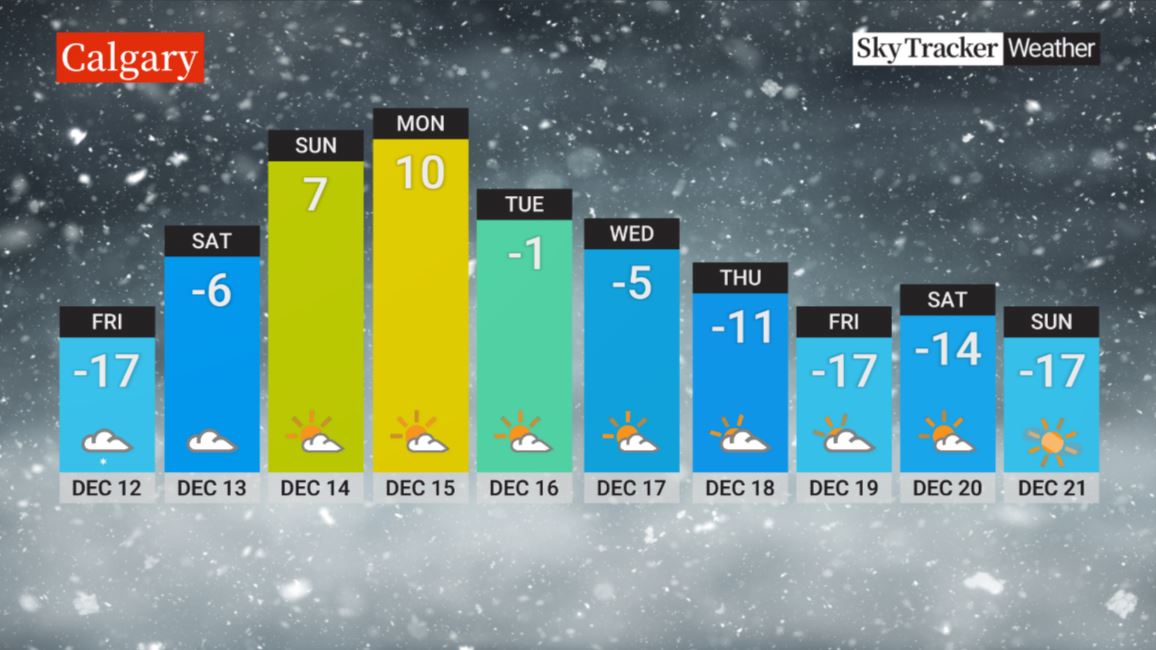
Thursday’s forecast high in Calgary is -17 C, but by Monday, a chinook is forecast to roll in and the temperature is forecast to spike to 9 C.

In Edmonton, the temperature is forecast to climb from -21 C on Thursday to just -1 C on Monday.
In Lethbridge, freezing rain Thursday morning is forecast to change to snow later in the day as the temperature plunges to -21 C overnight.
Environment Canada warns that snow and strong winds are also expected to make driving difficult in some areas, such as along the Trans Canada Highway in the southeastern parts of the province, and motorists are being urged to postpone non-essential travel until conditions improve.
“What you’ve got mixed in here is freezing rain, some falling flurries, blowing flurries, bit of a wind — the wind really kicking up blows those flurries around and impacts visibility,” said Global Calgary traffic reporter Leslie Horton.

Get daily National news
People who do need to travel are being told to pack an emergency kit in their vehicle.
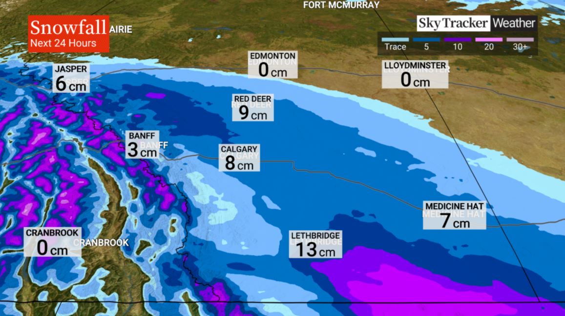
A second band of snow arrives on Friday, bringing up to five centimetres to the Calgary area, with a bit more in the Foothills and mountain parks.
“We’ll get a little relief come Sunday and definitely Monday,” Prendergast said. “But you’re going to want to soak up Monday because when we look at our 10-day forecast, temperatures head right back to where they are right now.”
By the middle of next week, the mercury is forecast to again drop into the minus-teens in Calgary and Edmonton.
However, “the temperatures and winds generally moderate upward compared to the Thursday and Friday cold snap,” said Global Calgary weather specialist, Joelle Tomlinson. “That means wind chills won’t be as extreme, until next Thursday, when the wind chill will drop into the minus-30s.”
The extreme cold has prompted both the City of Calgary and the City of Edmonton to activate their “extreme weather response,” working with organizations such as the Salvation Army and other organizations to open more overnight shelter spaces and daytime warming centres to help protect the cities’ more vulnerable populations.
People who do venture out are also being warned that the extreme wind chills also increase the risk of frostbite.
“The first thing we tend to see is frost nip, a sort of cold, red skin, but if it progresses to deeper layers of the tissues, that’s actual frostbite, which is frozen skin,” said Stuart Brideaux, a public education officer with Alberta Health Services.
“If treated relatively quickly, it can be relieved and (people) move on without further injury. But it can cause loss of tissue or loss of even amputation, as well as generalized body hypothermia.”

Repair crews in both Edmonton and Calgary have also been called out to a growing number of water main breaks and burst pipes believed to be caused by the plunging temperatures.


Comments
Want to discuss? Please read our Commenting Policy first.