
A special weather warning was issued by Environment Canada Monday afternoon, warning of heavy snowfall to parts of southern Alberta.

A Pacific low pressure system is moving into Washington State Tuesday morning, bringing with it 15 to 25 centimetres of snow.
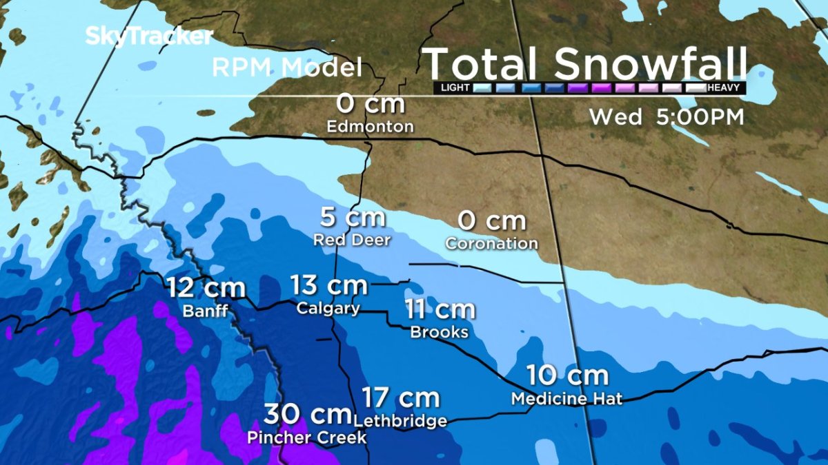
It will begin in western regions and spread eastward in the Lethbridge and Brooks regions in the afternoon. Heavier amounts of snow are expected in western areas like Strathmore and Vulcan.
Heavy snow will continue to fall through Wednesday before it tapers off Wednesday evening.
As the system develops, warnings may be extended to surrounding regions.
Snowfall warnings are issued when snowfall accumulations of greater than 10 cm fall in 12 hours.
Rapidly accumulating snow will make travel difficult. Visibility may be suddenly reduced at times in heavy snow. There may be a significant impact on rush hour traffic in urban areas.
In their special weather statement for Calgary, Environment Canada says the Pacific low pressure system that will move in Tuesday is still somewhat unpredictable.
“There is still a fair bit of uncertainty as to the exact path and speed of this low. At this moment, meteorologists are expecting anywhere from 10-25 centimetres of snow to fall from Tuesday morning until Wednesday evening.”
An earlier snowfall warning for Banff National Park has ended. Significant snowfall is no longer expected
Wind warnings were issued for Lethbridge and areas west of that city warning of gusts in excess of 100 kilometres per hour.
“Damage to buildings, such as to roof shingles and windows, may occur. Loose objects may be tossed by the wind and cause injury or damage. Be prepared to adjust your driving with changing road conditions due to high winds.”


The city of Calgary and much of Alberta have been experiencing unusually warm weather for the first half of December. With the exception of one day, daily highs in Calgary have been between 5 to 16 degrees above average and the city has not officially recorded any snow.* (*snow that fell on Dec. 15, hit parts of the city away from the Environment Canada weather station which records data)
Highs for the next week will swing the other direction in Calgary, with some days forecast to only warm up to -12 C, which is closer to the average overnight low.
The good news is Calgary is now in great shape for a white Christmas. Any snow that falls over the next few days will not melt since daytime highs are likely to remain so low.
Want your weather on the go? Download Global News’ Skytracker weather app for iPhone, iPad and Android.
- McLean accuses Calgary third-party advertiser of ‘whipping votes’ in favour of rezoning bylaw
- Canadian curler Chelsea Carey says don’t compare me to Jennifer Jones
- Firefighters battle blaze at vacant house in northwest Calgary
- 7 sent to hospital after carbon monoxide poisoning incident in northwest Calgary
Comments