

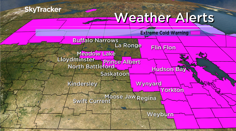
Arctic high brings extreme cold to central Saskatchewan into Friday.

Extreme Cold Warning
Environment Canada has issued an extreme cold warning for the Prince Albert, Melfort, Yorkton, Hudson Bay, Canora, Wynyard, La Loche, Uranium City, Pelican Narrows areas as well as parts of southeast Saskatchewan.
A very cold arctic ridge of high pressure will build in from the Yukon Thursday night.
Temperatures will plunge into the -30 neighbourhood with wind chills of -40 to -50 possible into Friday morning.
READ MORE: Extreme cold warning in parts of Saskatchewan
For the latest weather alerts download the Global News Skytracker weather app for iPhone, iPad or Android.
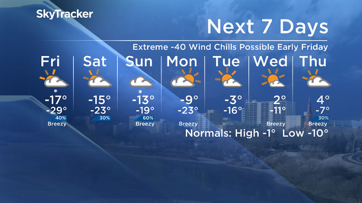
Saskatoon Forecast
Today
It was a cool start to the day in Saskatoon with the mercury falling back to -26 this morning.
-36 is what it felt like this morning with wind chill under mostly clear skies before a sun-dominated day kicked in with temperatures warming up toward the -20s by noon.
We’re only expecting to warm a few degrees warmer under mostly sunny skies as an arctic ridge of high pressure moves in.
Tonight
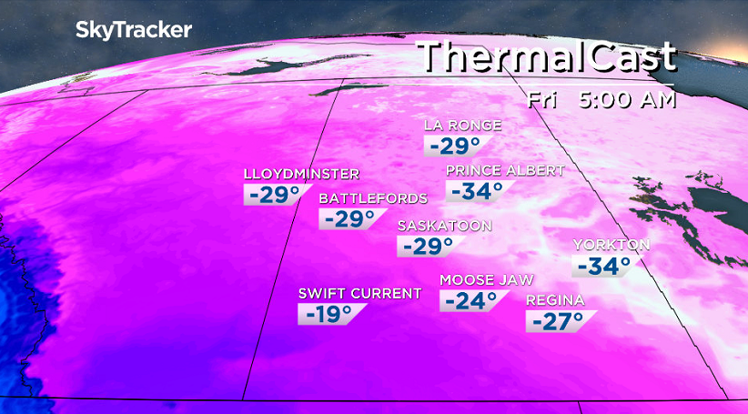
That ridge will cool us quickly tonight with temperatures falling right through the -20s toward the -30s overnight under clear skies.
Wind chills may reach or get very close to extreme cold warning criteria of -40 by morning, depending on how quickly a deck of clouds moves in and moderates conditions.
Friday
It looks like the clouds will likely move in by morning, so wind chill values -35 to -40 can be expected to start the day.
Cloudy skies will stick around for the day with a chance of flurries later in the afternoon and into the evening as we rise to a daytime high around -17 or so.
Weekend
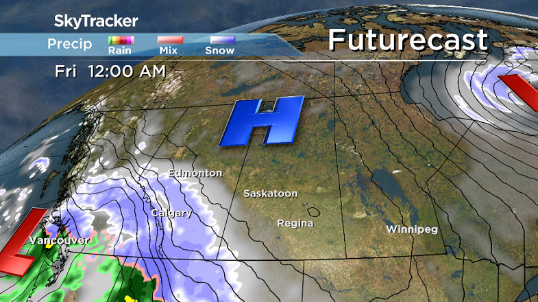
The push of Pacific moisture that will bring in a chance of snow late Friday may continue overnight into early Saturday before it moves out along with the clouds to likely give us some midday sunny breaks.


Clouds are expected to return Saturday afternoon and stick around on Sunday with a good chance of snow during the day as a system slides by south of the province.
Daytime highs are expected to bound up about two degrees at a time into mid-minus teens on Saturday and even milder for Sunday.
Work Week Outlook
A big warm up is on the way next week as we head into the middle of the month with daytime highs returning into minus single digits Monday and Tuesday before warming above freezing by the middle of the week under a mix of sun and cloud.
IN PHOTOS: Saskatchewan digs out from crippling blizzard
This Your Saskatchewan photo was taken by Bill Allen in Ralph:

Saskatoon weather outlook is your source for Saskatoon’s most accurate forecast and is your one stop shop for all things weather for central and northern Saskatchewan with comprehensive, in depth analysis that you can only find here.
- ‘Shock and disbelief’ after Manitoba school trustee’s Indigenous comments
- Invasive strep: ‘Don’t wait’ to seek care, N.S. woman warns on long road to recovery
- ‘Super lice’ are becoming more resistant to chemical shampoos. What to use instead
- Canadian food banks are on the brink: ‘This is not a sustainable situation’
Comments