EDMONTON — Severe thunderstorms could hit central Alberta Friday mid-afternoon into the evening and parts of southern Alberta could be hit even harder Saturday.

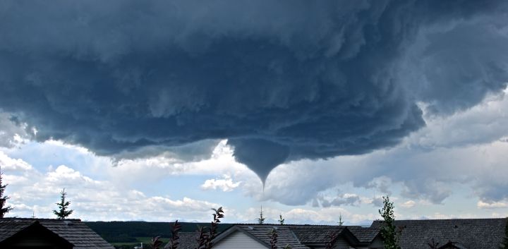
Weather models are predicting active weather just days after a tornado touched down outside Calgary, roughly 10 kilometres north of Priddis. The Capital Region was hit by a short but powerful hail storm Thursday afternoon.
READ MORE: Tornado touched down southwest of Calgary: Environment Canada
Significant weather parameters were hinting at another active and severe weather day for the area, extending east-northeast of Calgary into parts of east-central Alberta Saturday afternoon and evening.
The models indicated an unstable atmosphere with a lot of energy and fuel to feed the storms on Friday afternoon. There will also be differential wind speeds and directions in the upper levels of the atmosphere.
Those conditions are concerning because they could lead to the development of rotating severe storms with the possibility of producing what’s called “supercell” thunderstorms.
READ MORE: Thunderstorms 101: Derechoes, supercells, multi-cells… what it all means
The main threats from supercell storms are significant lightning, large-sized hail and heavy showers with the risk of localized flooding.
Friday’s models also showed enough evidence to support possible tornado activity.
READ MORE: What to do during a tornado warning
All weather warnings and watches should be taken seriously. Keep a close eye on your local Global forecast for the most up-to-date and accurate information about this event.
To get real-time weather for your area, download the Global News Skytracker weather app.
Environment Canada will also be updating any weather warnings and watches.
Comments