
UPDATE: All snowfall warnings ended in Saskatchewan

SASKATOON – It’s a messy start to the long weekend – parts of Saskatchewan remain under a snowfall warning.
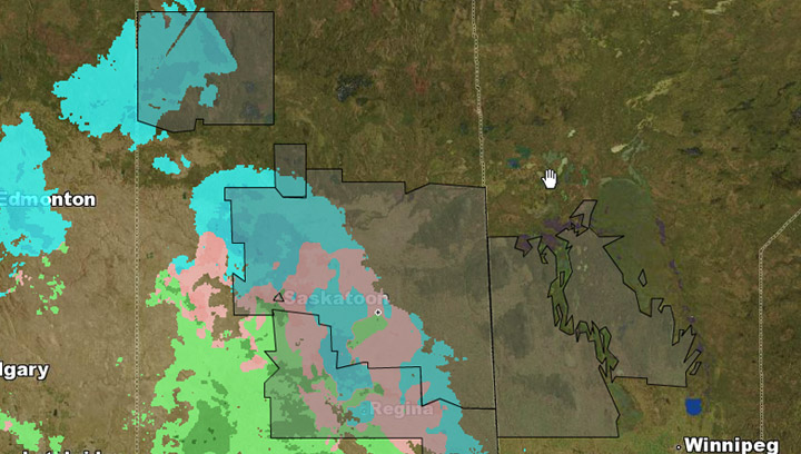
Environment Canada says a storm system that developed over Southern Alberta is tracking through Southern Saskatchewan today and into tonight.
A large amount of precipitation is expected with the system over the next 24 hours.
The greatest amount of snowfall is expected along and north of Highway 16, where 10 to 15 centimetres of snow is expected.
For regions outside the warned areas, snowfall amounts of up to 5 centimetres is expected before the snow tapers off or changes to rain.
Snow will continue to fall across parts Saskatchewan tonight before tapering off Saturday morning.
A freezing rain warning that had been issued for Saskatoon, Regina, Moose Jaw and areas around those cities has ended.
For the latest weather conditions, download the SkyTracker weather app for iPhone, iPad or Android.


Snowfall warning ENDED for:
- Humboldt – Wynyard – Wadena – Lanigan – Foam Lake
- Île à la Crosse – Buffalo Narrows – Beauval
- Kamsack – Canora – Preeceville
- La Ronge – Prince Albert Nat. Park – Narrow Hills Prov. Park
- Yorkton – Melville – Esterhazy
- Hudson Bay – Porcupine Plain
- Martensville – Warman – Rosthern – Delisle – Wakaw
- Melfort – Tisdale – Nipawin – Carrot River
- Prince Albert – Shellbrook – Spiritwood – Duck Lake
Freezing rain warning ENDED for:
- Saskatoon
- Regina
- Fort Qu’Appelle – Indian Head – Lumsden – Pilot Butte
- Moose Jaw – Pense – Central Butte – Craik
- Moosomin – Grenfell – Kipling – Wawota
- Outlook – Watrous – Hanley – Imperial – Dinsmore
- ‘Shock and disbelief’ after Manitoba school trustee’s Indigenous comments
- Several baby products have been recalled by Health Canada. Here’s the list
- Canadian food banks are on the brink: ‘This is not a sustainable situation’
- Invasive strep: ‘Don’t wait’ to seek care, N.S. woman warns on long road to recovery
Comments