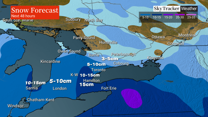
Another snowstorm is set to impact part of southern Ontario on Friday, though accumulation amounts overall are expected to be much less than what was experienced last week.

Global News meteorologist Anthony Farnell said snow will begin in the early morning across southwest Ontario and spread into Kitchener-Waterloo and Hamilton by mid-morning.
The Greater Toronto Area will start to see snowfall around noon.
“The snow will be accompanied by winds in the 20 to 40 km/h range which will cause some blowing snow,” Farnell said.
“Everything tapers off during the evening as the system quickly moves east.”
Accumulation amounts will be highest across the western GTA, Hamilton and in the Niagara Region where up to 15 cm is expected, Farnell said.
“For the rest of the GTA, it looks like closer to 5 cm with locally up to 10 cm possible,” he said.

Get breaking National news
As of Thursday afternoon, Environment Canada had placed Hamilton and northern Niagara Region under a snowfall warning, advising of 10 to 15 cm for those areas with locally 15 to 20 cm.
Elsewhere, winter weather travel advisories were issued for areas stretching from parts of the GTA south to Windsor.
“Temperatures will remain below freezing on Friday but the good news is now that we’re later in March, the higher sun angle means that light snow has a harder time accumulating on road surfaces during the day,” Farnell noted.
Through next week, temperatures will remain slightly below seasonal.
“Old man winter isn’t done with us just yet,” Farnell said.


Comments
Want to discuss? Please read our Commenting Policy first.