

Much of southern Ontario will be hit with another “blast of winter weather” beginning Friday, Global News meteorologist Anthony Farnell says, with the temperature playing a “critical role” in determining just how much snow will fall.

Environment Canada placed a large swath of the region under a winter storm watch Thursday ahead of the system, with areas in the southwest under special weather statements.
By the early evening, some of the winter storm watches were upgraded to warnings.
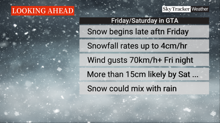
Farnell said the system will begin to impact southern Ontario Friday afternoon.

Get breaking National news
“The worst of the snow will be during the late evening in the GTA where snowfall could accumulate at up to 4 cm per hour,” he said.
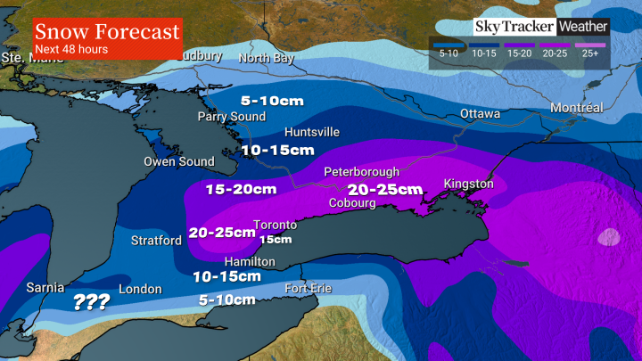
“The temperature will once again play a critical role in this storm and with it hovering within a degree above or below freezing, snow amounts will vary significantly. It will be milder near the Lake Erie and Ontario shores, including downtown Toronto, where closer to 15 cm looks more likely.”
North of Highway 401 it will be a bit colder, Farnell said, with amounts there closer to 20 cm or 25 cm locally.


“The very heavy wet snow will stick to just about everything and with winds that could gust over 70km/h, power outages are also possible Friday night,” Farnell added.
Into the weekend, it’s expected to be mild, meaning the snow will quickly begin to melt after the storm moves through.

Comments
Want to discuss? Please read our Commenting Policy first.