

An arctic ridge of high pressure over British Columbia is pushing bitter cold air throughout the province bringing the potential for snow across the South Coast on Friday.

Environment Canada says an extreme cold warning is up for B.C.’s Peace River regions with forecasts of wind chill values to -40 C. Arctic outflow warnings have been posted for B.C.’s central and northern coasts, with the wind chill predicted at -20 C.
In addition, arctic outflow warnings are in place for Whistler and the Fraser Valley with the potential for wind chill values of -20 C Friday morning.
Meanwhile, Snowfall warnings are in effect for the Malahat, Inland and East Vancouver Island and special weather statements for Metro Vancouver, Southern Gulf Islands, Howe Sound, Sunshine Coast and the Fraser Valley.
Read more: First the snow, then the ice: B.C. commuters warned of slick roads, plunging temperatures

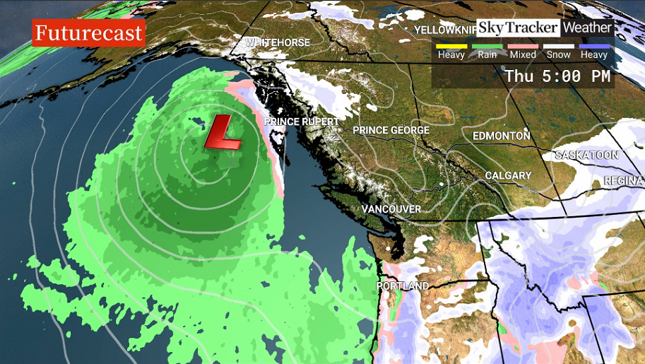
There is still uncertainty around snowfall for the South Coast on Friday.

Get daily National news
The swirling low is expected to track from the Alaska Panhandle down the B.C. coast over the next 36 hours. Its centre is offshore, but the eastern edge of the system will touch the coast as it passes by.
The forecast suggests a small shift toward the east would cause heavy snow for Vancouver Island and some snow the Lower Mainland, while a small shift to the west would bring some snow for Vancouver Island and no snow or minimal amounts for the Lower Mainland.
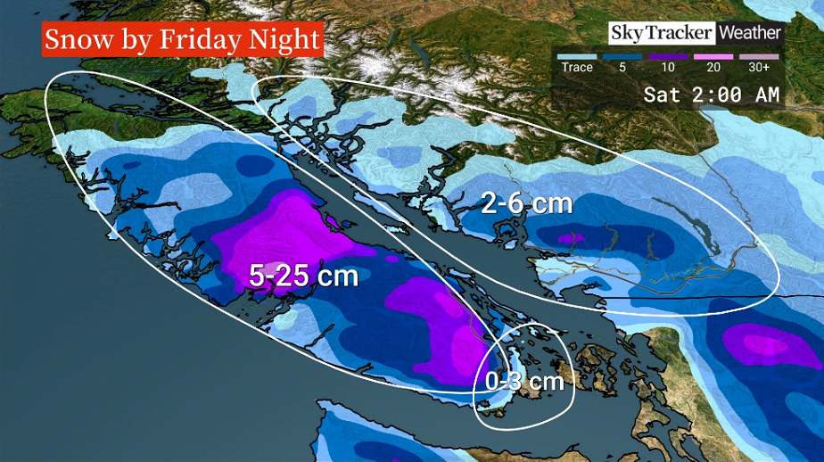
Greater Victoria could see up to three centimetres of mixed snow and rain by late Friday.


The hardest hit region will be from the Malahat, Inland Vancouver and along the east coast from Duncan to Campbell River with 5 to 15 centimetres possible into Friday evening. Another 5-10 centimeters could fall in a few isolated areas overnight.
Winds are expected to gust between 60 and 80 kilometres per hour in the afternoon and evening, mainly across southern Vancouver Island.
If the worst arrives in the Lower Mainland, flurries are possible on Friday morning, with zero to six centimetres of snow or mixed with rain Friday afternoon and evening.
Two to six centimetres could fall on Friday evening, as temperatures continue to hover around zero.
Wind could gust up to 60 kilometres per hour in the Fraser Valley and southern Metro Vancouver.

Tuesday’s storm has prompted red alerts from Canada Post, indicating carriers are not delivering in parts of the Fraser Valley, Metro Vancouver and in Nanaimo and Parksville on Vancouver Island. Mail carriers will try to deliver in the Comox Valley, although delays are likely, Canada Post said.
Residents should also be wary of slippery conditions, possible power outages on Friday, along with ferry delays and cancellations.
The system is expected to move on after Friday night with sun in the forecast for Saturday.
–With files from The Canadian Press
Comments
Want to discuss? Please read our Commenting Policy first.