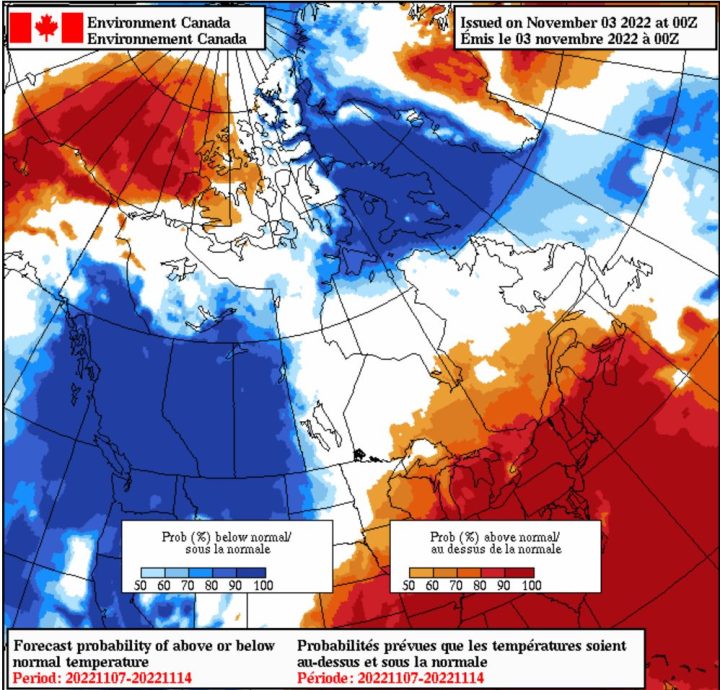
It has been an unusual fall season for Canada, with some parts of the country experiencing “summer-like” conditions in contrast to other provinces seeing early winter snowstorms.

For people in eastern Canada, it was a warm weekend, with record-high temperatures recorded for the month of November.
In the capital city Ottawa on Saturday, mercury levels hit 23.4 C, breaking an 84-year record for the warmest Nov. 5 since records began, according to Environment Canada.
The Greater Toronto Area (GTA) set a new all-time November high Saturday of 25.2 C recorded at Pearson international airport, as did Hamilton, with 24.7 C.
Meanwhile, Montreal shattered its previous November record, experiencing the city’s hottest day for the month on Saturday as the temperature rose to 24.3 C.
New November records were also set on Sunday across New Brunswick, Nova Scotia and western Labrador, according to Environment Canada.
“It is unusual in the sense that we’re not used to seeing these summer-like conditions this late in the month,” said Ross Hull, Global News meteorologist.
“It can happen, but this is certainly taking it to the extreme.”
A large area of high pressure off the coast in the Atlantic, called the Bermuda High, is pumping in the warmth from the United States, causing the above-normal temperatures, particularly in Ontario and Quebec, said Geoff Coulson, warning preparedness meteorologist with Environment Canada.
“This pattern does occur from time to time, but not necessarily with the intensity that we’ve seen with this most recent spate of temperatures, but also with the previous warm spells that we’ve seen so far this fall,” he told Global News.
The high-pressure ridge and the warm sea surface temperatures off of the Atlantic coast are driving the current warm weather pattern, added Hull.
While temperatures are expected to drop and normalize in the coming days and weeks, this warm fall which will last a while, has pushed Canada’s seasons, possibly delaying winter and spring going forward.
Snowstorms in western Canada
While the eastern provinces have been warming up, it’s a different story in the West, with snowfall warnings in place in Alberta, British Columbia and Saskatchewan.
At least for the last week or so, the cold air has been entrenched in Western Canada, said Hull, adding that it was not abnormal to see snow in November across the prairies.
“It is sort of a typical thing that we start to see as we move through the month of November, that Arctic air starting to push across the country, and that’s what we’ve seen.”
Over the last couple of days, much of British Columbia, Alberta and Saskatchewan have experienced temperatures below normal, Coulson told Global News.
“There’s been a real difference between what we’ve been seeing in parts of Eastern Canada temperature-wise versus what we’ve been seeing the last few days out West, where it certainly is looking to feel much more like winter conditions as opposed to the almost summer-like conditions we’ve been experiencing in parts of Ontario and Quebec.”
What’s next?
After the record warmth that people in Eastern Canada experienced over the past two days, it will be “back to reality” by next weekend, with temperatures hitting close to where they should typically be for November, said Hull.
“You’re not going to be seeing any more record highs,” he added, with forecasts showing temperatures dropping by roughly 15 degrees or more.
While southern Ontario and portions of southern Quebec will continue to see above-normal temperatures through this week, there will be a shift in the weather pattern towards the middle of November, before warmer conditions creep back in at the end of the month, said Coulson.
Canadians in eastern parts of the country should prepare themselves for some fluctuating weather patterns for the rest of November and going into December, Coulson and Hull say.
“The cold air will take over for a period of time into next week and then we’ll likely see another warm-up and then another drop, so it’s going to be back and forth across the East, said Hull.
Coulson agreed, saying: “It does look like a fair amount of variability in the temperature forecast for Ontario and Quebec over the course of the next few weeks.”
As for Western Canada, there will be similar changing weather patterns, with some warmer conditions raising temperatures closer to the average, before more Arctic intrusions come in through the month of December, said Hull.
This is typical for a transition season, where “we see this sort of ebb and flow of the cold and the warm air battling it out,” he said.
- Posters promoting ‘Steal From Loblaws Day’ are circulating. How did we get here?
- Canadian food banks are on the brink: ‘This is not a sustainable situation’
- Video shows Ontario police sharing Trudeau’s location with protester, investigation launched
- Solar eclipse eye damage: More than 160 cases reported in Ontario, Quebec


Comments