
It may seem like winter has come early to much of Canada with temperatures well below seasonal and bouts of snow dotting the landscape. The good news is that we are going to get a break in November before the Arctic winds reload and winter arrives for good.

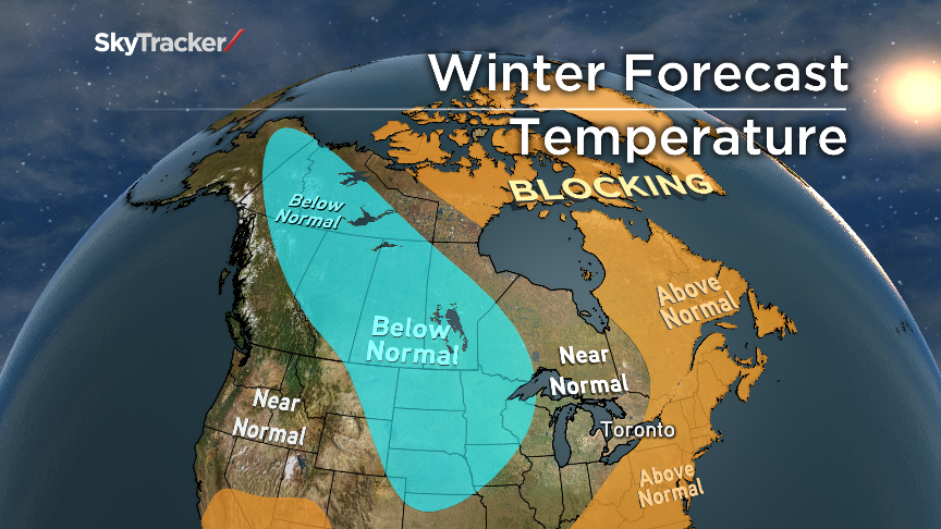
My winter forecast assumes that a weak El Nino will develop in the equatorial Pacific and high-latitude blocking will be present for at least half of the winter across Greenland and the rest of the Arctic.
High latitude blocking is a large stable ridge of high pressure that can set up over the Arctic or Greenland and persist for day or weeks at a time. It is often the result of mild air being displaced north, which forces colder air south and diverts the jet stream south as well. The “Greenland Block” is often associated with a cold weather pattern for eastern North America.
Solar activity has been remarkably low considering we are at the peak of the solar cycle and this also favours blocking.
The Atlantic ocean is still in a very warm phase, plus there haven’t been many hurricanes this summer and fall to cool the waters near the Maritimes. The warm Atlantic water is the main reason why the winter forecast includes above seasonal temperatures for parts of Quebec and most of Atlantic Canada this winter.
Snow in Durham, Ontario. (Ron Irwin)
Ontario will see a more typical winter with some warm spells but also several Arctic outbreaks especially January and early February. Lake effect snow is already making news considering it’s only October and there are still leaves on some trees. I do expect another round of strong lake effect late November or early December when the cold returns.


The storm track will also be active from the Ohio Valley through Ontario and Quebec especially later in the season. This means above normal precipitation and above normal snowfall for the two provinces. I also think there will be lots of messy storms with a mix of everything… at least for southern Ontario.
The prairie provinces of Manitoba, Saskatchewan, and Alberta are in for a more classic winter with prolonged periods of severe cold. Temperatures here will average below seasonal from December into March. The foothills of Alberta will likely see above normal snowfall because of cold air ringing out moisture as it rides up from the plains. BC is expected to be close to normal but with increased precipitation and snowfall typical to the past several winters in that region.
Comments