
Following the winter storm that hit B.C.’s South Coast Wednesday night and into Thursday, there is still a lot of varied weather to come.

“This is a classic west coast winter storm where the two air masses battle it out for domination over the South Coast,” Global BC meteorologist Kristi Gordon said.
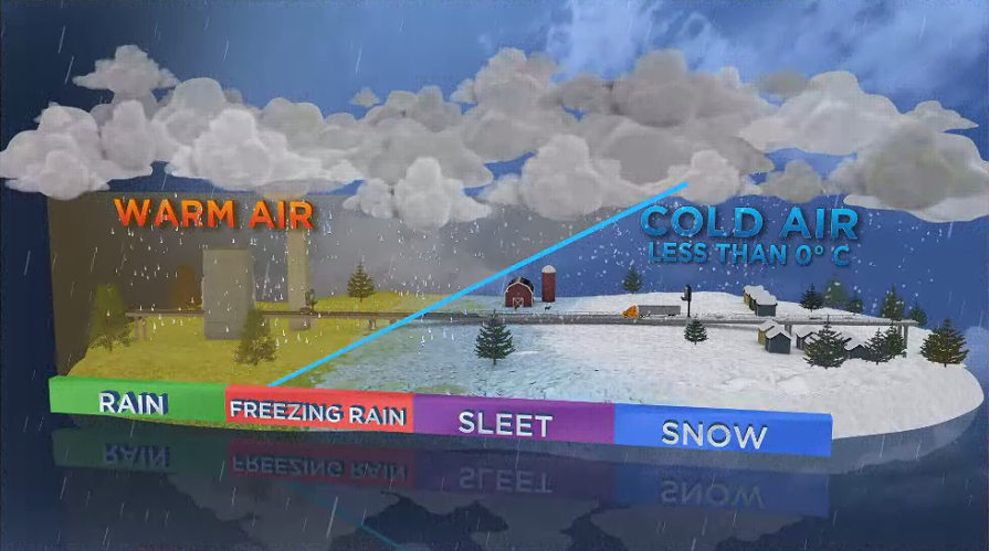
“In the beginning, the cold Arctic air dominates and precipitation falls as snow across the region. Then, slowly but surely, the Pacific storm takes over the region as it moves in from the west bringing milder air. The precipitation eventually transitions from snow to rain or freezing rain.”
Freezing rain is created when mild moves over cold air near the surface. Rain falls through the milder air but then freezes on when it hits the cold surfaces near the ground.
Gordon said there is still the possibility of 10 to 30 cm of snow along the Sea to Sky Highway and near Hope by late Friday morning.

Get daily National news
For other areas, freezing rain is going to be an issue Thursday night and into Friday.
The Fraser Valley, Howe Sound and eastern Metro Vancouver could all receive freezing rain, making roads icy and dangerous, Gordon said.
There is also a slight risk across Vancouver Island, she added.


Heavy rain will also hit Metro Vancouver Thursday evening through Friday morning, Gordon said.
About 30 to 60 mm is expected to fall and temperatures will remain steady at 4 C overnight, Gordon added.
The combination of rain and melting snow will likely cause pooling water on roads and possible minor/localized flooding in low-lying areas, she said.

Wind will also be an issue for Metro Vancouver, especially by the water, Gordon added.
Strong winds will pick up Friday morning and could reach between 70 to 80 km/h.
Read more: Freezing rain looms for Vancouver Island after storm knocks out power for more than 20,000
This could cause possible power outages and ferry delays Friday, Gordon warned.
The winds will ease by late Friday afternoon.
The next chance of snow is Saturday morning but Gordon said only about one to three centimetres is expected to fall at this time.
Comments
Want to discuss? Please read our Commenting Policy first.