


Many parts of B.C. are bracing for rain Wednesday as the next atmospheric river is expected to make landfall in the province.

The next storm will arrive overnight Wednesday and into Thursday, Global BC meteorologist Mark Madryga said.
The next storm after that is still on track for Saturday and early Sunday, Madryga added, and then another is still in the forecast for next Tuesday.

All three are expected to be atmospheric rivers, although rainfall amounts are expected to be lower than the Nov. 13 to 15 event.
Madryga said there will be a gap of dry weather Friday and Friday night.

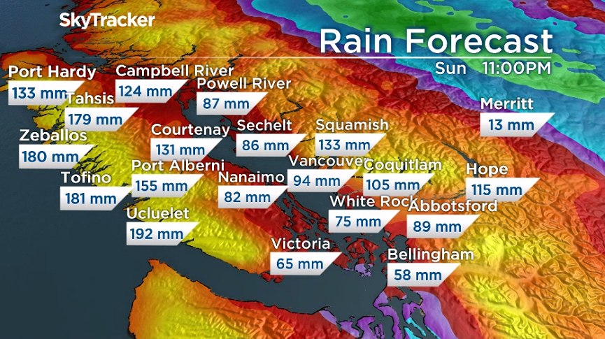
In a computer model, total rainfall amounts for many locations from both Thursday and Sunday’s storms could reach almost 200 millimetres across parts of west and north Vancouver Island.

Get daily National news
However, much of the Lower Mainland will receive 60 to 120 millimetres, far less than the close to 300 millimetres Hope received in the Nov. 13 to 15 event in just over two days.
Madryga said some areas may receive more than these estimates while others may indicate a worst-case scenario.
Heavy rain and soaring freezing levels are expected to melt snow in the mountains. This will cause greater runoff and increase the impact of these storms.
- After experiencing 2016 wildfire, Fort McMurray survivor addresses evacuation trauma
- Edmonton organizations watch out for seniors during hot, smoky conditions
- Calgary air quality on Friday among the worst cities on earth
- Thorhild, Westlock counties declare state of agricultural disasters due to rain


Environment Canada has issued a slew of warnings for the upcoming days.
Seven areas of the province are under a rainfall warning for this first atmospheric river expected through Thursday, including Metro Vancouver, the Fraser Valley, Howe Sound, inland sections of the North Coast and Central Coast and north and west Vancouver Island.
Some areas, like the Fraser Valley, could see between 50 and 80 millimetres of rain, while other regions like the outer coast of Vancouver Island will get between 100 and 150 millimetres of rain.
The storm is also expected to bring strong winds.

Whistler and Howe Sound are also expected to receive up to 15 centimetres of snow during this next storm.
This strong weather system will also bring a winter storm to parts of the Columbias, Environment Canada says.
Snow will begin over the Trans-Canada Highway – Eagle Pass to Rogers Pass section Wednesday afternoon and transition to heavy snow by Thursday morning. Accumulations of up to 30 centimetres of snow can be expected by Thursday evening, according to Environment Canada.
An additional 10 centimetres can be expected on Friday, possibly bringing totals reaching 40 centimetres.
—with files from Kristi Gordon
Comments
Want to discuss? Please read our Commenting Policy first.