
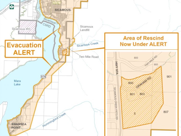
An evacuation order for the Two Mile Road wildfire that’s burning near Sicamous, B.C., has been rescinded.

The Columbia Shuswap Regional District issued the downgrade on Tuesday. The order had been affecting 32 properties within the District of Sicamous.
Located just two kilometres south of Sicamous, the fire is estimated at 1,200 hectares and is classified as out of control.
The properties now on evacuation alert include:
- all properties within the District of Sicamous to the south of the Trans-Canada Highway, south of Stadnicki Road and east of the Sicamous Narrows and Mara Lake.
- areas east of Highway 97A south to and including the community of Swansea Point.
According to BC Wildfire, the blaze is moving in a northeast direction, up and away from town.
“Rank 2-plus fire behaviour primarily observed above the community; however, the fire has not seen wind for nine days,” said BC Wildfire.
“Although precipitation is in the forecast, winds may become a challenge if it changes the direction of the fire.”
Fifty-nine firefighters, three helicopters and 10 pieces of heavy equipment are battling the fire. Also assisting are crews from the Sicamous and Swansea fire departments.

Below is a list of other wildfires of note throughout the Okanagan, Shuswap, Similkameen, Boundary and West Kootenay regions:
Brenda Creek
More than 30 firefighters are still battling this wildfire, which was discovered on July 14.
Located around 40 kilometres west of West Kelowna, south of the Okanagan Connector, the fire size at 824 hectares has remained unchanged for days.
Three helicopters and 12 pieces of heavy equipment are also battling the blaze.
On Sunday, the fire received 1-2 millimetres of scattered rain.
BC Wildfire says while that helped, conditions are forecast to return to being warm and dry over. The BCWS also said there were strong winds recently, but fire guards and crews have held the perimeter successfully.
An evacuation order issued on July 15 by the Regional District Okanagan-Similkameen (RDOS) remains in effect for Electoral Area H.
An evacuation alert also remains in place for Eneas Lakes, Pennask lake, Trepanier and Pennask Creek provincial parks.
The Regional District of Central Okanagan (RDCO) has also issued an evacuation alert for 18 properties, three recreational camping areas and Crown land within West Electoral Area, south of Highway 97C and northwest of Peachland.

Bunting Road
Located 41 kilometres north of Lumby, this fire is estimated at 4,932 hectares and is classified as out of control.
Eight firefighters and two helicopters are battling the blaze, which received a good amount of rain on Sunday.
However, visibility is poor due to wildfire smoke and the helicopters have been grounded.
BC Wildfire says crews have reported seeing people drive past closures into the active fire area, “creating a safety hazard not only to themselves but also to the responders in this active worksite.”
An evacuation order for 66 properties along Mabel Lake Forest Service Road (10,000 block to 17,000 block) is still in effect. The road is closed between the 14 and 40-kilometre marks.
Also, an expanded evacuation alert for the 3,000 to 6,000 block of Mabel Lake FSR is also still in effect.
Visit the Regional District of North Okanagan (RDNO) for more information.

Crazy Creek Gorge FSR

Get daily National news
This lightning-caused fire is located around 29 kilometres north of Sicamous and is estimated at 2,446 hectares.
It’s classified as being out of control, and is burning on a high, north-facing slope in a remote location.
BC Wildfire says Rank 4 and Rank 5 behaviour has been seen, and due to thick smoke and close to zero visibility, it hasn’t been able to update the fire’s size. However, it will try to do so using satellite imagery.
Last week, the Columbia-Shuswap Regional District issued an evacuation order for the communities of Queest Village and Pete Martin Bay.

Garrison Lake
Located 33 kilometres southwest of Princeton, this wildfire is estimated at 8,175 hectares and is classified as out of control.
BC Wildfire says rain on Sunday lessened fire behaviour, but that aggressive fire behaviour is occurring due to heavy winds.
“The fire is within close proximity of the highway, and the Ministry of Transportation and Infrastructure is continuing to assess Highway 3 for risks to public safety,” said BC Wildfire.
An evacuation alert (affecting one property) and an evacuation order (affecting many properties) are in effect for the Kennedy Lake area.
BC Wildfire says due to visibility issues from smoke, an accurate size of the fire perimeter is not available.
“We have notified BC Parks about this fire as it has moved slightly into E.C. Manning Park, and BC Parks has issued a partial closure of E.C. Manning Park as a result,” said BC Wildfire.

Hunakwa Lake
This fire is estimated at 2,700 hectares and is located around nine kilometres southeast of Seymour Arm.
It is classified as out of control, and 27 firefighters and two helicopters are battling the blaze.
The fire received around three millimetres of rain on Sunday, which helped calm it down, but BC Wildfire says the size has been difficult to estimate because of smoke, which has also grounded the helicopters.
An evacuation order is in effect for part of Seymour Arm (Tranquility Bay and properties east of Seymour Arm Bay Road at Bughouse Bay, including Tipman Road and Bradley Road and boat-in only properties).

Michaud Creek
This fire is estimated at 8,847 hectares and is burning south of Edgewood, along the west shore of Lower Arrow Lake.
BC Wildfire says the area received three millimetres of rain overnight, and that cooler temperature plus increased humidity have improved burnable surface fuels.
However, it says larger fuels and deep soil remain highly combustible and would need significant rainfall to improve conditions.
Still, BC Wildfire says crews made good progress on the north control line, and the objective is to prevent it from growing that way.
The south flank and the north flank of the Renata Creek wildfire have been mostly inaccessible for aircraft to smoke conditions, but it is being monitored by satellite imagery.
Seventy-six firefighters are battling the blaze, as are five helicopters and 20 pieces of heavy equipment.
On Tuesday, the Regional District of Central Kootenay removed an evacuation alert for the wildfire.


Nk’Mip Creek
This fire, located near Osoyoos, is now estimated at 16,005 hectares, up recently from 13,000 hectares.
BC Wildfire says the increase is due to several days of fire growth following days of crews being unable to map it because of wildfire smoke.
“Conditions have returned to a drying trend with relative minimum humidity at 25 per cent and daily high temperature of 30 degrees,” BC Wildfire said on Tuesday.
“Winds are expected to be variable 5-15 km/h in the morning and southwest 10-20 km/h by the afternoon.”
One hundred and 86 firefighters are on scene, as are six helicopters and 24 pieces of heavy equipment.
The fire has prompted several evacuation orders and restrictions from the Osoyoos Indian Band, the Regional District of Okanagan-Similkameen and the Regional District of Kootenay Boundary.
There is also an area restriction order that was issued on July 24.

Octopus Creek
Located around 11 kilometres south of Fauquier, the fire is estimated at 18,337 hectares.
Like the Michaud Creek wildfire, this fire received three millimetres of rain.
And on Tuesday, the Regional District of Central Kootenay reduced a portion of an evacuation order for Fauquier to an evacuation alert.
Sixteen properties south of the approximate 15.5 km mark on Applegrove Road will remain on evacuation order, while 152 properties will be reduced to an evacuation alert.
“This reduction to an alert means residents can return to their properties, but must be prepared to leave on short notice should conditions change,” said the regional district.
Eighty-two firefighters and five helicopters plus 12 pieces of heavy equipment are battling the blaze.

Thomas Creek
This fire is located around three kilometres northeast of Okanagan Falls.
It is estimated at 10,280 hectares and is classified as out of control.
On Monday night, the fire grew on the southeast corner, where crews are now working to establish containment and tie the escape back into fireguards.
“Active fire behaviour and growth continues to be observed along the north flank in the Derenzy and McLean Clan Lake area,” BC Wildfire said on Tuesday.
“The new size estimate reflects the growth observed in these areas. This growth did not impact the control objectives set out for this flank of the fire.”
BC Wildfire says weather conditions have returned to a drying trend with relative minimum humidity at 25 per cent and daily high temperature of 30 C.
Winds are expected to be variable 5-15 km/h in the morning and southwest 10-20 km/h by the afternoon.
Twenty-seven firefighters are on scene, as are 34 military personnel, three helicopters and 23 pieces of heavy equipment.
A total of 724 properties are under an evacuation alert, while another eight are under an evacuation order.

Three Valley Lake
Located around 18 kilometres southwest of Revelstoke, this fire is estimated at 500 hectares, up from 309 hectares.
BC Wildfire says the fire is showing Rank 1 and Rank 2 behaviour to the south, and is slightly more aggressive to the north.
It also said rocks dislodging from steep cliffs on the east side of Three Valley Gap are causing a safety hazard.
An evacuation order is in effect for Three Valley Lake, including the area bordering the north side of the Trans-Canada Highway.
An evacuation alert is in effect for two properties west of the Trans-Canada Highway.
Sixteen firefighters are battling the blaze.

White Rock Lake
This out-of-control fire is located around 34 kilometres north of Vernon, near the small community of Westwold, and is estimated at 32,500 hectares.
BC Wildfire says there were variable amounts of precipitation over the past 48 hours, but given the current drought conditions, the minimal precipitation provided only a short reprieve.
A weak southwest flow will bring drier, warmer air back to the region, which will quickly dry out forest fuels. For Tuesday afternoon, winds will be southwest 10-20 km/h, easing down into the evening with temperature highs near 30 degrees.
There are several evacuation alerts and orders in effect because of the fire which can be seen on the following area websites:
- Thompson-Nicola Regional District
- Columbia-Shuswap Regional District
- Regional District North Okanagan
- Okanagan Indian Band
- Regional District Central Okanagan
One hundred and 36 firefighters, 99 of which are from Quebec, 11 helicopters and 42 pieces of heavy equipment are battling the blaze.
Comments
Want to discuss? Please read our Commenting Policy first.