A new tourism app aims to help Indigenous communities reconnect with the land.

Souta Calling Last, who is from Kainai First Nation and Southern Piikani First Nation, runs an educational non-profit organization called Indigenous Vision.
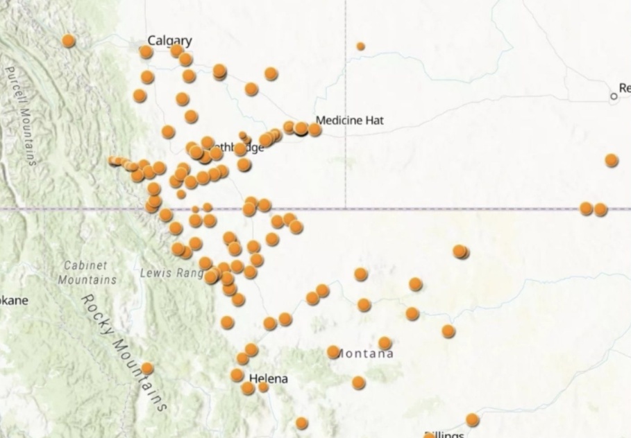
Calling Last has spent the last four years at Indigenous Vision building an interactive tourism app that shares the locations of historical Blackfoot land sites throughout Alberta, Saskatchewan, Manitoba, Montana and Wyoming.
The new app includes historical sites such as the teepee rings located in Crowsnest Pass and medicine wheels located in Alberta and Wyoming.
“I have possibly found sites that have never been found before,” Calling Last said.
Calling Last said she’s received a few phone calls from people reporting to have an interesting Blackfoot landmark on their property that was never discovered before.
“We’ve had a few of those calls, which is really awesome,” she said.

Calling Last says that it’s in her best interest to keep these sites protected.

Get breaking National news
When discovering new sites, Calling Last says that she looks for “Napi effigies.”
Napi is frequently portrayed as a trickster, a troublemaker and a foolish being, but he is also considered a well-intentioned demigod responsible for shaping the world the Blackfoot live in, and would frequently help the people or teach them important knowledge.
The medicine wheels located in Alberta and Wyoming are examples of Napi effigies.
“It’s really cool to see how far the history goes,” Calling Last said. “A new site discovered is really exciting.”
To find the sites, she spends hours at a time combing through locations online by using two satellites.
“Sometimes it takes a week, and some sites just pop at you the first time around.”

Calling Last describes new discoveries as “really exciting” but says that not all historical landmarks will be shared with the public.
“Some sites may not have protection in place so I would only share it with tribal leaders, culture keepers and for academic purposes.”
Calling Last says that only 10 per cent of Blackfoot traditional territory is covered in maps.
“I must have 112 sites and those sites include about 500 places just for Blackfoot,” she said.
Calling Last hopes to expand the app in the future to include music by Indigenous artists, an audio travel guide, and push notifications to alert drivers of nearby landmarks.
“It’s essentially us taking our ancestral data and and using it to adapt to today’s life and world,” she explained.

Rachel Snow, a legal consultant from Morley, Alta., says it’s important to name the landmarks their original Indigenous names.
“It demonstrates connection to the land.”
Snow says the Indigenous Vision app may help Indigenous people reconnect with their culture and land. She also explained that if individuals know their history, then they already know these sites.
Calling Last describes the app as a tool to help communities determine their own land developments.
Another goal Calling Last intends to achieve is to ensure that all Indigenous youth know “how strong we are.”
“When you see my map and you’re inside those orange points, you are firmly on our homeland.”
Calling Last expects to launch the app this year.


Comments
Want to discuss? Please read our Commenting Policy first.