

It’s going to be a stormy start to the new year for many parts of B.C. with heavy snow, rain and strong winds.

Meteorologist Yvonne Schalle said this “parade of storms” will carry into the weekend and strong winds will accompany each storm.
The winds have already affected BC Ferries sailings, so any travellers are advised to check their route before heading out.
Mountain passes in the province will see heavy rain change to snow as the temperature drops, Schalle said.
In addition, a series of systems will continue to produce snow for the North Coast inland.
Environment Canada has issued a snowfall warning for Williston and Highway 97 – Pine Pass with at least 15 cm expected to fall by Saturday morning.
The North Coast, including Stewart, could see about 25 cm of snowfall through Saturday.

Highway 3 from Hope to Princeton and the Coquihalla Highway are also under a snowfall warning New Year’s Day with 15 to 25 cm expected by Saturday morning.

Get breaking National news
A winter storm warning remains in effect for Highway 3, from Paulson Summit to Kootenay Pass with hazardous winter conditions expected, according to Environment Canada.
This series of storms will move across the B.C. Interior over the next couple of days bringing “significant snowfall” to many mountain passes.
According to Avalanche Canada, there is a high avalanche risk on the South Coast and Sea-to-Sky Mountains, meaning the risk of human-caused avalanches is very likely.
There are warning at all three levels of the mountains – Alpine, treeline and below and travelling into the backcountry or out-of-bounds is not recommended.
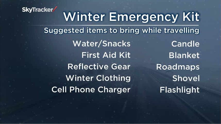
In addition, mountain highway closures are possible over the next few days as crews will likely have to perform avalanche control. Anyone travelling should be prepared with extra warm clothing, snacks, water and at least a cell phone charger.
Read more: A parade of storms in B.C. to welcome 2021


Other areas of the province can expect it to get wet with rainfall warnings in effect for Howe Sound, Metro Vancouver including the North Shore, Coquitlam and Maple Ridge.
Environment Canada said rain will be heavy at times especially Saturday through Saturday night.
Total rainfall amounts of 100 mm or more are forecast with localized flooding in low-lying areas possible.
The heavy rain has prompted a high streamflow advisory Vancouver Island, including west, central, south and east regions, and for the South Coast, including tributaries around the Sunshine Coast, Howe Sound, Squamish, Lillooet River, North Shore Mountains, Metro Vancouver, the Fraser Valley and surrounding areas.
The River Forecast Centre says in the past 48 hours, some locations on Vancouver Island have received up to 75 to 200 millimetres of precipitation.
Freezing Levels are expected to rise and could reach up to 2,400 metres, according to the centre.
Rivers are forecast to reach their highest flows on Saturday or Sunday depending on the timing and intensity of the rainfall, however, there is a possibility that additional storms will arrive early next week.
North and east Vancouver Island and the North Coast are also under a wind warning with strong winds expected to sweep across the region.
Environment Canada said the winds could down trees and power lines and lead to outages.
Comments
Want to discuss? Please read our Commenting Policy first.