

Colder Arctic air is destined to sweep southwards through British Columbia in the coming days.

Environment Canada has issued a snowfall warning for parts of Highway 3 from Hope through Princeton via the Allison pass.
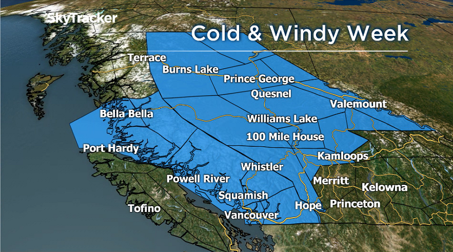
And the agency has issued special weather statements for a vast swath of the interior, stretching from the South Coast northeast to the Peace Region.
In the Central Interior, northerly winds will blow to 50 km/h on Tuesday, resulting in plummeting temperatures during the day.
By late in the week, nighttime temperatures in Prince George are forecast to drop to -25 C, which is 16 C below average.
Kamloops and Kelowna will experience the incoming chill by mid week with morning low temperatures later in the week expected between -10 C and -15 C.

Get daily National news
In the Lower Mainland, as Arctic air sweeps towards the coast on Tuesday, strong northeasterly outflow winds will blow in the places like the Fraser Valley, Howe Sound and across the Southern Gulf Islands.


By Wednesday night through Friday, windchill values in the Fraser Valley will be in the range of -8 C to -12 C.
As the cooler air begins to slide into Metro Vancouver from the Interior on Tuesday morning, it will collide with patchy moist and unstable air over Metro Vancouver.
This is likely to result in several showers of rain or mixed rain and snow during Tuesday morning’s commute.
With precipitation showery in nature, the impacts will vary from place to place.
At this time, accumulations of snow are not expected on the roadways, but updates will be ongoing.
Comments
Want to discuss? Please read our Commenting Policy first.