
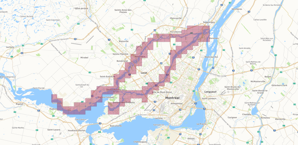
New flood maps by the Communauté métropolitaine de Montréal (CMM) have outlined the regions that it finds now fall into Quebec’s floodplains.

The maps, adopted Thursday by the CMM’s council, put hundreds of residents from Sainte-Marthe-sur-le-Lac at risk of recurring floods.
READ MORE: New maps would put hundreds of Sainte-Marthe-sur-le-Lac homes in flood plain
It also includes parts of Île-Bizard, Saint-Eustache as well as several northern parts of the Island of Montreal, including a large portion of the borough of Pierrefonds-Roxboro.
“The 2017 and 2019 spring floods, as well as climate change, require fast and up-to-date flood risk mapping to support flood management and ensure people’s safety,” the organization stated in a press release.
WATCH BELOW: Off island mayors calling on Quebec and Canada to step up flood relief

To date, more than 150 maps have been made since 2017 for the areas surrounding the Rivière des Prairies, the Rivière des Mille-Îles and the northern sector of Lac des Deux Montagnes.
READ MORE: Quebec premier forms committee of ministers to create flood action plan

Get breaking National news
Mapping of the floodplains near the Richelieu and Saint-Jacques rivers, Lac Saint-Louis, the St. Lawrence River and the rest of Lac des Deux Montagnes are expected to be completed by December 2020.
“CMM will work with the government to support the management of flood zones and ensure the safety of people and their properties,” said Montreal Mayor Valérie Plante in a statement.
Lac des Deux Montagnes was hit particularly hard by the 2019 floods and requires “short- and medium-term action in order to protect the municipalities.”

Zones considered at high risk have the potential to be flooded again within the next 20 years. CMM notes that residents who live in the area for 25 years have at least a 72 per cent chance of experiencing at least one flood.
Therefore, the building of new residential homes will not be permitted in the areas deemed most at risk.
READ MORE: Data reveals scope, damage of spring floods in Quebec and New Brunswick


Zones considered low risk could experience flooding within the next 20 to 100 years.
Anyone living in the low-risk area for 25 years has between a 22 per cent and 72 per cent chance of experiencing at least one flood.
As such, new constructions will be permitted, depending on circumstances specific to each area.
READ MORE: Quebec floods: army will stay to help with cleanup operations
Some areas that have experienced flooding in the past could see a recurrence in the next 100 years.
Anyone living in this zone for 25 years has at most a 22 per cent chance of being flooded again during that time.
New constructions will be permitted, depending on the circumstances.
However, the Quebec government announced earlier this week it was forbidding new constructions in high-risk flood plains and would not allow homeowners whose properties were flooded to rebuild if damage exceeded 50 per cent of the total value.
READ MORE: Quebec government gives green light to rebuild dike in Sainte-Marthe-sur-le-Lac
The Quebec government gave $5.5 million to CMM to update the flood maps following the 2017 spring floods.
It will then be up to the provincial government to decide whether to approve the maps — and what to do next.
WATCH BELOW: Quebec on helping flood victims

Comments
Want to discuss? Please read our Commenting Policy first.