


A mandatory evacuation order was issued for more areas of Mackenzie County Wednesday as an out-of-control wildfire continues to burn south of High Level.

Shortly before 1 p.m. Wednesday, everyone in the area of La Crete Ferry Campground and two kilometres east of the campground was ordered to evacuate the area immediately. Anyone on the east side of the Peace River is asked to head towards La Crete. Those on the west side should head out of the area along Highway 35, the alert stated.
Just before 1:30 p.m., another alert was issued which stated those located just east of the area under evacuation order should prepare to leave on a moment’s notice. That includes everyone north and south of Highway 697 to Range Road 164 and Steep Hill Creek.
“The fire did jump Highway 35 and it’s a precautionary evacuation to Peace River that’s between the fire and the municipality,” Mackenzie County Reeve Josh Knelson told Global News Wednesday afternoon. “For now, we just want to clean out the camp sites, do these things sooner than later.”
“It was just in preparation… if it were to cross the river — I mean, we are hoping that it wouldn’t but a fire this size, you’ve got to treat it with a lot of respect.”
Shortly before 8:30 p.m. on Wednesday, the Alberta Emergency Management Agency issued an update on behalf of Mackenzie County and said “the area of evacuation has expanded for this wildfire.”
“Now, everyone in the area of La Crete Ferry Campground east to Range Road 164, and north and south of Highway 697 must evacuate immediately,” the update said. “Everyone evacuating this area must travel east on Highway 697 and evacuate to La Crete where a reception centre has been set up.”
The Heritage Centre on Township Road 1060 in La Crete is where the reception centre has been set up. Evacuees are asked to go there to register and receive further information. Anyone who needs help complying with the evacuation order is asked to call 780-928-4447.
Knelson said everyone is staying on high alert.
“And make sure that everybody that is at home is ready to leave if they, all of a sudden, need to leave and keep calm,” Knelson said. “The biggest thing is not to panic.”
READ MORE: Alberta wildfire continues to grow but is spreading away from High Level
The alerts came as heavy smoke cloaked parts of northern Alberta on Wednesday morning.
The smoke reduced visibility and vehicles were coated in ash in La Crete, about 150 kilometres south of the 1,300-square-kilometre (130,000-hectare) Chuckegg Creek fire near High Level.
“The Chuckegg Creek fire experienced extreme fire behaviour yesterday due to continued hot, dry weather,” said a Wednesday morning update. “The south part of the fire took a 10-kilometre run towards Paddle Prairie, and the north part of the fire was active to the south of Watt Mountain.

Get weekly health news
“Resources are being mobilized to assess the situation around Paddle Prairie.”
Later Wednesday, officials said the south part of the Chuckegg Creek fire crossed Highway 35, south of High Level. It’s approximately six kilometres east of Highway 35. The province said the highway was closed in both directions north of High Level between the Zama City turnoff and the Northwest Territories boundary due to “dynamic conditions related to wildfires.”
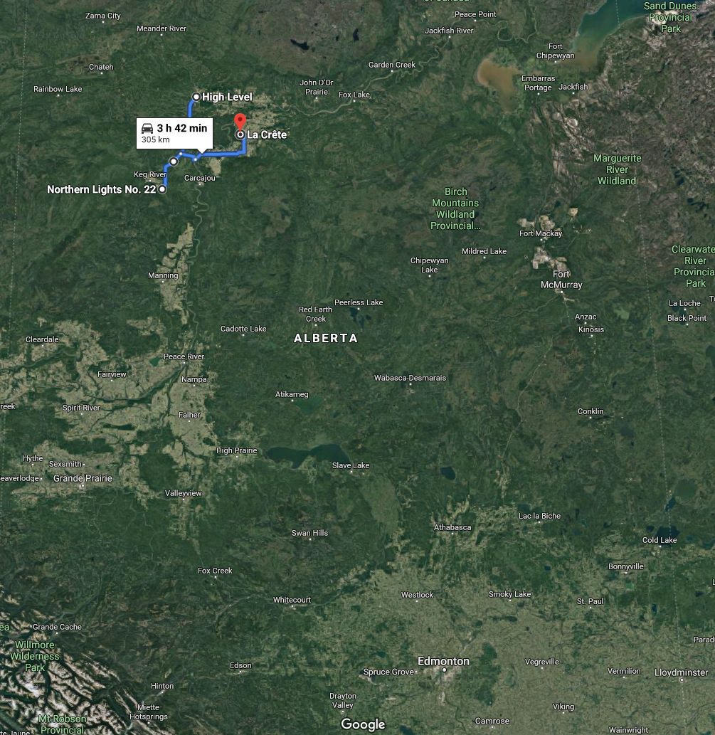
Alberta Transportation has also closed Highway 697 leading east to a ferry.
Officials said the firebreak around High Level continues to keep flames away from the town.


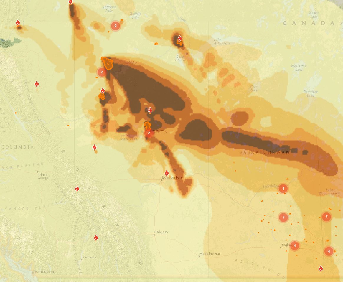
On Wednesday morning, the Alberta Wildfire map showed five wildfires burning in the northwest corner of the province, including the blaze that forced about 5,000 people from the town of High Level and surrounding communities to evacuate a week and a half ago.
North of Slave Lake near the centre of the province, there are currently three fires, with two classified as out of control.
READ MORE: Climate change report warns of more extreme weather events in Alberta
Wildfires on the other side of the province are also leading to smoky conditions in the Fort McMurray area. There are four fires — two north of Fort McMurray and two further south near Conklin — burning in the northeast.
The air quality across northern Alberta is expected to remain at a high or very high risk level on the Alberta Environment air quality health index (AQHI) all day Wednesday.
Alberta Health measures the AQHI on a scale of one to 10, with higher numbers meaning a greater health risk.
A 10+ is considered “very high risk,” at which point Alberta Health suggests people avoid strenuous activities outdoors, adding that children and the elderly should avoid outdoor physical exertion during this time.
The smoke is expected to push the Edmonton region to a 6, or “moderate risk,” on Wednesday.
WATCH BELOW: Mike Sobel’s Wednesday, May 29, 2019 early morning weather forecast for Edmonton, Alberta and the surrounding area.

The wildfire smoke has drifted across Western Canada as far as the Vancouver area.
Environment Canada issued a special air quality statement for the City of Edmonton on Wednesday at 4:25 p.m. “due to high levels of air pollution.
“Hot and sunny conditions have resulted in increasing ground-level ozone concentrations in the above regions,” the weather agency said. “High risk AQHI values are expected to persist for a few hours.”
READ MORE: Alberta wildfire haze reaches Metro Vancouver as smoke season comes early
Experts have forecast a summer of high wildfire danger across Western Canada and have warned that climate change will continue to worsen fire seasons in the future.
— With a files from The Canadian Press
Comments
Want to discuss? Please read our Commenting Policy first.