
It’s shaping up to be a dry summer for B.C.’s streams and rivers, with the province warning that provincial snowpacks are verging on 40-year lows for mid-May.

The B.C. River Forecast Centre says that snow levels have dropped significantly since the beginning of the month due to persistently hot weather and rapid melt.
“We’re a few weeks ahead of normal across the province and quite low snowpack for this time of year pretty much everywhere across the province,” said Dave Campbell with the centre.
“It’s among the lowest years we’ve seen ever.”
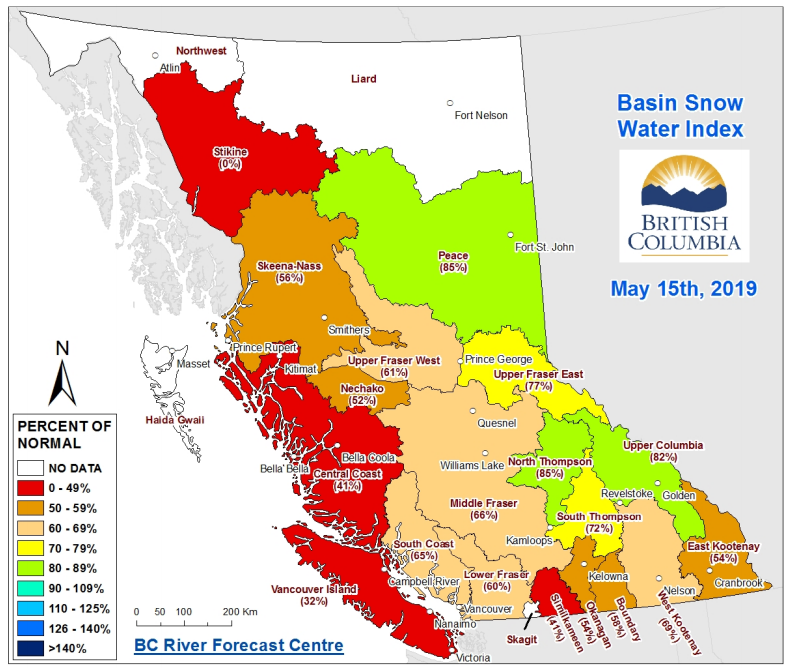
The centre said snowpacks range from just 32 per cent of normal on Vancouver Island to a high of 85 per cent of normal in the North Thompson. Provincewide, snowpacks are sitting at an average of 64 per cent of normal, it said.
The centre said that, typically, 15 to 25 per cent of accumulated snow melts by mid-May, while this year most sites have seen 50 to 60 per cent of snowpacks melt.

Get daily National news
Potential trouble areas include the Upper Fraser West, Nechacko, Lower Fraser, East Kootenay, Okanagan, Boundary, Similkameen, South Coast, Vancouver Island and Skeena-Nass regions, it said.
On the positive side, the early melt and lower snowpacks mean a reduced likelihood of flooding in B.C.’s Interior.
- Should trees have rights? A B.C. municipality debated the idea
- First Nations chiefs call for inquiry into Ontario wildfire response
- AI data centres have 4 in 5 Albertans concerned over environment, electricity costs: Poll
- How the Northern Tornadoes Project helps verify twisters as Alberta on track for record year


The centre says larger watersheds should be at peak flow now, though it adds that flooding due to extreme rainfall remains a possibility.
However, the centre also said that the province’s west is looking at “an increased likelihood of above-normal late-spring to early-summer temperatures” and that the major risk is now low water levels across much of the province.
READ MORE: ‘The risks related to snow melt are lower’ — Below-normal snowpacks in Okanagan dampen flood risks
“Along with 2015 and 2016, this year is amongst the lowest May 15 snowpacks that have been observed in B.C. over the past 40 years,” said the agency in its May 15 Snow Survey and Water Supply bulletin.
“Spring and summer weather will continue to play a key role in whether or not low flows emerge through the summer.”
In April, the centre said the 2019 season shares a combination of risk factors — including low snowpacks, persistent dry weather and El Nino conditions — with the record-breaking drought year of 2015.
Comments
Want to discuss? Please read our Commenting Policy first.