

I hope you used some spicy salsa to bring some heat to a cold Cinco de Mayo – that was the coldest day in almost a whole month. April 11 was slightly cooler.

Before we talk about cool weather, I want to highlight the beginning of summer storm season has managed to begin. Manitoba had its first tornado of the year, the second in Canada, last Friday southeast of Lettelier.
RELATED: Manitoba’s first tornado of 2019 touches down
No damage was reported but Tornado No. 1 is in the books.
This week won’t knock your hat off by strong winds or big storms of any kind. Generally it’ll be quiet and cool.
Snow was registered at the airport early Monday morning and during the morning commute. It doesn’t look like there will be more snow this week but perhaps a few showers could hit the city.
After a clear, sunny day on Tuesday a band of precipitation will likely move across southern Manitoba bringing a few showers overnight and potentially into the early morning in the southeast. No significant precipitation is expected here.
There is a better chance for some rain closer to the weekend, on Friday night. There’s some decent model agreement that we’ll get some rain at that time even though the numbers vary.
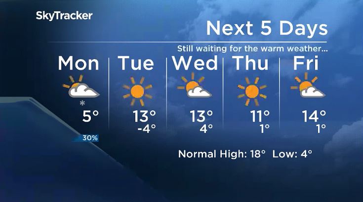
As you can see, things don’t exactly heat up quickly and that will be the case in the long run as well.

Get breaking National news
The 8-14 day outlook from Environment and Climate Change Canada looks like this.
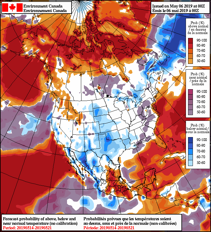


Manitoba is kind of in between the warmer and cooler than normal weather. Keep in mind though, that this map is based on normal temperatures for each region. So, if Winnipeg is going to be getting “normal” weather for that week, you can look forward to temperatures getting up close to 20 C rather than peaking at 6 C.
While it may be slow in coming, we know there will be hot weather soon enough, which will bring the risk of more tornadoes. Here is a refresher before twister season officially arrives.
WATCH: What to do in case of a tornado

Comments
Want to discuss? Please read our Commenting Policy first.