

-50 wind chills return with the biggest blast of cold of the year to kickoff February.

January 2019
January 2019 was way warmer and drier than normal in Saskatoon.
The city saw half of its normal precipitation throughout the period with only 7.2 millimetres of rain, freezing rain and melted snow at the airport when normally 14.8 millimetres falls.
Daytime highs trended almost two degrees above average with overnight lows about half a degree above normal, meaning temperatures were overall about a degree and a half warmer than seasonal.
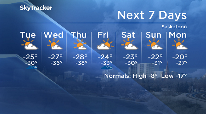
Saskatoon forecast
Monday
-38 is what it felt like Monday morning in Saskatoon with wind chill as light snow continued to fall after just over 10 centimetres was reported in the city over the weekend.
Arctic air surged in with the snow with a breezy northeasterly wind continuing into the morning hours as temperatures hovered around -26 degrees right into the noon hour.
The mercury is expected to make it a few degrees further into the warmer end of the -20s with light snow continuing right through the afternoon.
Monday night
2 centimetres of snow is expected to fall with a push of moistures swinging through Monday night as conditions cool back to around -28 C overnight.
Tuesday
-38 is what it’ll feel like Tuesday with wind chill as you’re heading out the door in the morning under mostly cloudy skies.
Sunny breaks are likely to return by the end of the day as we climb up to an afternoon high around -25, but it will feel like the mid -30s all day with wind chill.

Wednesday-Friday
Skies will eventually get carved out by an arctic high-pressure system building in, potentially as soon as Wednesday morning, which could allow temperatures to fall as far as the mid -30s to start the day.
Clear skies into Thursday morning will the region to around -38 with wind chills into the -50s before clouds return on Friday and warm daytime highs from being barely into the -20s to the mid -20s to finish the week.


Weekend outlook
The clouds that roll in on Friday will clear out on Saturday, allowing morning temperatures to fall back into the -30s with daytime highs remaining in the mid -20s under partly cloudy skies through the weekend.
Brenda Gawluk took the Feb. 4 Your Saskatchewan near Furdale:

Saskatoon weather outlook is your source for Saskatoon’s most accurate forecast and is your one-stop shop for all things weather for central and northern Saskatchewan with comprehensive, in-depth analysis that you can only find here.
For weather on the go, download the Global News SkyTracker Weather App for iPhone, iPad or Android.
Comments