

A blast of snow and wind slides in mid-week.

Saskatoon forecast
Tuesday
Temperatures fell through the morning from -1 at around 4 a.m. down to -8 by 9 a.m. before warming up toward -5 heading into the noon hour.
A real mixed bag of conditions started the day with some snow overnight, then skies started to clear with a bit of mist forming mid-morning that reduced visibility down to two kilometres at times.
Mostly sunny skies linger into the afternoon as we climb up to an afternoon high just shy of the freezing mark.
Tuesday night
Mostly clear skies Tuesday evening will be replaced by clouds rolling in overnight as conditions cool back to -6.

Get breaking National news
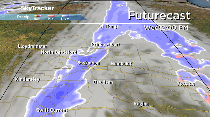
Wednesday
-10 is around what it’ll feel like with wind chill Wednesday morning, but mostly cloudy skies will linger during the morning with snow beginning midday as a cold front pushes in.
Temperatures should hop up to -1 during the day with a blustery west-northwesterly wind picking up to 30 km/h with gusts in excess of 50 km/h at times in the afternoon before skies clear later on.
Thursday-Friday
Another round of clouds pushes in on Thursday before sunshine returns across the region as an upper ridge rebuilds on Friday.
Daytime highs should spike up above the freezing mark both days as warm air spills back in across the Prairies.


Weekend outlook
Mild air will stick around for the weekend ahead as an upper ridge builds back in, keeping skies partly-to-mostly sunny with daytime highs around the freezing mark.

The Your Saskatchewan photo for Dec. 11 was taken by Jodi Lemaigre in La Loche:

Saskatoon weather outlook is your source for Saskatoon’s most accurate forecast and is your one stop shop for all things weather for central and northern Saskatchewan with comprehensive, in depth analysis that you can only find here.
For weather on the go download the Global News SkyTracker Weather App for iPhone, iPad or Android.
Comments
Want to discuss? Please read our Commenting Policy first.