
The Cool Creek wildfire has grown again.

What started as a 100-hectare wildfire on August 15th is now estimated to be 13,000 hectares in size, according to the B.C. Wildfire Service.
“Very smoky conditions continue in the Cool Creek area,” B.C. Wildfire Service information officer Steve Kada said on Saturday morning. “But the weather is sort of turning into our favour, with cooler temperatures and higher relative humidity, but winds are in the 10 to 20 kilometre-an-hour range.”
The fire is burning in what’s considered the back-country, and no communities are being threatened. Kada said “the fire is burning in steep and inaccessible terrain, so safety for crews is our No. 1 goal. There are some areas that are unsafe to work in.”
On Friday, the Regional District of Okanagan-Similkameen issued an evacuation order for Cathedral Lakes Lodge, which is located approximately one hour west of Penticton. This was the lodge’s second evacuation order of the summer, with the first taking place August 1st because of the Placer Mountain wildfire.
The fire has a massive evacuation alert, mainly aimed at ranchers and cattle, and a restriction order. The BCWS said the restriction order was placed “to protect public safety and ensure the safety of firefighting personnel.”
The BCWS added that the restriction order will remain in place until noon on Sept. 15 or until it is rescinded. Under this order and Section 11(2) of the Wildfire Act, a person must not remain in or enter the restricted area without the prior written authorization of an official designated for the purposes of the Wildfire Act, unless the person enters the area only in the course of:
- Travelling to or from his or her principle residence that is not under an evacuation order;
- Travelling to or from leased property for the purposes of accessing a secondary residence or recreational property that is not under an evacuation order;
- Travelling as a person acting in an official capacity;
- Travelling for the purpose of supporting wildfire suppression activities; and
- Engaging and/or participating in agricultural activities pertaining to livestock management on private or leased property.
Below is a list of notable fires in the Okanagan, Similkameen and Boundary regions:
OKANAGAN
Darke Creek
- Location: 12 kilometres northwest of Summerland.
- Size: Approximately 5.5 hectares.
- Status: Active, considered held.
Mount Gottfriedsen
- Location: Pennask Mountain, near Highway 97C, 24 kilometres west of West Kelowna.
- Size: 615 hectares.
- Cause: Lightning.
- Status: Active, but classified as under control. Sixty-seven personnel on site, which includes military personnel, along with four pieces of heavy equipment.
- BCWS notes: “The underlying indices are still high, so any increases in wind will create the potential for aggressive fire behavior. Beetle kill stands in the fire area will be challenging if fire activity spots in to one of those stands.”
Harris Creek Forest Service Road
- Location: 16 kilometres southeast of Lumby.
- Size: 700 hectares.
- Cause: Lightning.
- Status: Active, classified as out of control. One hundred and five personnel on site, including 60 from the Canadian military, along with nine pieces of heavy equipment and five helicopters.
Sugar Mountain
- Location: Four kilometres east of Sugar Lake.
- Size: 394 hectares.
- Cause: Under investigation.
- Status: Active, classified as out of control. Zero personnel on site though the fire is being monitored daily by aircraft.
- BCWS notes: “An area restriction order was put in place on August 4 and remains in force until the earlier of 12:00 noon on September 15 or until the order is rescinded. The order is for crown land in the vicinity of Sugar Lake (west of Sugar Lake). This order was put in place to address a public safety concern arising from the Sugar Mountain wildfire and in order to avoid interference with fire control.”
Mabel Creek
- Location: Six kilometres east of Mabel Lake.
- Size: 1,861 hectares.
- Cause: Under investigation; suspected lightning caused.
- Status: Active, classified as out of control. An area restriction order is in place for crown land in the vicinity of Mabel Lake.
Whip Creek
- Location: Three kilometres south of Mabel Creek wildfire
- Size: 504 hectares.
- Cause: Lightning.
- Status: Active.
Juliet Creek
- Location: 47 kilometres southwest of Merritt.
- Size: 1,238 hectares.
- Cause: Lightning.
- Status: Active, classified as out of control. Fifty-four personnel on site along with 11 pieces of heavy equipment. Air support available as needed.
- BCWS notes: “Planned ignitions on the northwest corner and the southern flanks of the fire were successful. Crews will be mopping up in the areas the planned ignitions occurred.”
SIMILKAMEEN
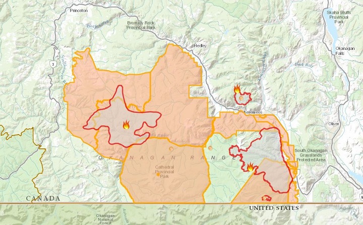
Cool Creek
- Location: 35 kilometres west of Keremeos.
- Size: 13,000 hectares.
- Cause: Lightning.
- Status: Active, classified as out of control. Eighteen personnel on site along with 17 pieces of heavy equipment. Air support available as needed.
- BCWS notes: “Areas of this fire are burning in steep, inaccessible terrain that is unsafe for crews to work and carry out suppression efforts. On Thursday, the fire spotted across the Ashnola Forest Service Road and exhibited aggressive fire behaviour. Crews and heavy equipment continued to build control lines and conduct small scale planned ignitions (conditions permitting) off the control lines.”
Old Tom Creek
- Location: Seven kilometres west of Olalla.
- Size: 527 hectares.
- Cause: Lightning.
- Status: Active, classified as out of control. Seventy-five personnel on site with 11 pieces of heavy equipment. Air support available as needed.
- BCWS notes: “Ground crews, heavy equipment and air tankers have been utilised to create new containment lines or tie into natural lines, roads and retardant drops. High winds resulted in an escalation of fire behaviour and saw some small growth of the fire. Heavy equipment will continue to assist ground crews in consolidation of control lines and completion of contingency lines.”
Snowy Mountain
- Location: 14 kilometres south of Keremeos.
- Size: 13,359 hectares.
- Cause: Lightning.
- Status: Active; classified as being held. Eight personnel on site.
- BCWS notes: “The steep terrain is inoperable in some areas, and poses a safety risk to firefighting personnel. Crews are being strategically placed where it is safe and where suppression objectives can be met.”
BOUNDARY
Lynch Creek
- Location: 25 kilometres north of Grand Forks.
- Size: 122 hectares.
- Cause: Under investigation.
- Status: Active; classified as under control. Thirty personnel on site with one piece of heavy equipment.
- BCWS notes: “This fire is in under control, meaning that the fire has received sufficient suppression action to ensure no further spread of this fire. Previoius evacuations have been rescinded.”
Bulldog Mountain
- Location: 32 kilometres northwest of Castlegar.
- Size: 1,145 hectares.
- Cause: Lightning.
- Status: Active. Twenty-two personnel on site, along with four helicopters.
- BCWS notes: “Aviation resources will be engaged as visibility allows. Machine guard is complete on the north flank of this fire. Hand ignition operations have been completed on the north flank to reinforce this guard. Crews continue to work the southwest flank of this fire.”
Syringa Creek
- Location: 16 kilometres northwest of Castlegar.
- Size: 1,423 hectares.
- Cause: Lightning.
- Status: Active.
- BCWS notes: “As smoke dissipates, this fire will become more visible from surrounding communities including Castlegar.”

Santa Rosa / Horns Mountain
- Location: Washington state and B.C.; 13 kilometres southeast of Christina Lake and 22 km southwest of Rossland.
- Size: Washington state (4,418 acres / 1,787 hectares) and B.C. (931 acres / 377 hectares).
- Cause: Lightning.
- Status: Active. Forty personnel on site, along with 11 pieces of heavy equipment.
- BCWS notes: “Small scale hand ignition operations occurred on the fire on the east and west flanks. Crews continue to make good progress on containment lines. Crews are working with the aid of heavy equipment to strengthen containment lines on the north flank of this fire. Crews are continuing to mop up the north flank of this fire by bring water along the containment line.”
- USFS notes: “Planned actions for the next operational period would be to complete burnout on the northwest flank of the fire. All other containment lines, crews will continue to hold, secure, and mop up where it is safe to complete objectives and meet mop up standards.”
Comments