
It’s blazing hot outside, but temperatures in the Okanagan will soon be dropping.

That’s good news for the B.C. Wildfire Service, which, for the last two weeks, has had its hands full with lightning-caused wildfires throughout the region. As of today, there are just five wildfires in the Valley, down from 16 when a lightning-filled thunderstorm rolled across the region on July 17, sparking fires left and right.
“Good progress is being made,” said BCWS information officer Marla Catherall. “Things are looking a little quieter out there.”
As an example of how things are quieting down, on Friday, the Mount Eneas fire near Peachland was classified as being held at 1,793 hectares, with 87 firefighters on site. Today, it’s now classified as under control at 1,790 hectares. Notably, the number of needed firefighters has dropped to 62.
With cooler weather on the way, even more progress is expected to be made.
“It does make a big difference,” said Catherall. “The hotter it gets, the higher the chance of flare-ups and that sort of thing, so it definitely helps. And also for our crews on the line as well; the temperatures have been quite hot for them. So the cooler it can get, the easier it will be on working conditions.”

Get daily National news
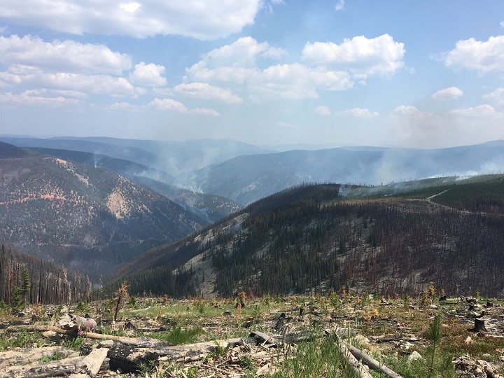
OKANAGAN wildfires
Goode’s Creek
- Location: 21 kilometres south of Kelowna, in Okanagan Mountain Provincial Park.
- Size: 1,370 hectares.
- Cause: Lightning.
- Status: Classified as out of control. Thirty personnel on site with air support as needed.
- BCWS notes: “Today’s objectives consist of patrolling and extinguishing any hot spots that are found.”
Mount Eneas
- Location: Four kilometres south of Peachland, immediately west of Highway 97.
- Size: 1,790 hectares.
- Cause: Lightning.
- Status: Classified as under control. Sixty-two personnel on site and two pieces of heavy equipment.
Frederick Creek
- Location: Okanagan Mountain Provincial Park.
- Size: 58.3 hectares.
- Status: Active. Never listed as a ‘fire of note’ by the BCWS.
Glenfir Road
- Location: 10 kilometres northwest of Naramata.
- Size: 100 hectares.
- Cause: Lightning.
- Status: Classified as being held. Twenty personnel on site with air support as needed. The Naramata Fire Department is on night shift.
Mount Conkle
- Location: Approximately six kilometres southwest of Summerland.
- Size: 118 hectares.
- Cause: Lightning.
- Status: Classified as being held. This fire has an extended perimeter due to all the fingers and bays.
SIMILKAMEEN wildfires
Snowy Mountain
- Location: Remote, 14 kilometres south of Keremeos.
- Size: 3,050 hectares.
- Cause: Lightning.
- Status: Classified as out of control. Forty-three personnel with three helicopters and three pieces of heavy equipment. There is an evacuation alert for two homes in Cawston and access routes in the vicinity.
- BCWS notes: “No planned ignitions were conducted by B.C. Wildfire Service on this fire yesterday. Fire behaviour was extremely active yesterday and was burning Rank 5/6 in some areas. The fire grew approximately 1000 hectares burning up a valley to the northwest away from the community of Cawston. Crews will be constructing a handguard north of Susap Creek to tie into an existing guard to the south of the creek. This fuel free line was 80 per cent complete at end of day yesterday. A machine guard is also being established to the east of the handguard.”
Placer Mountain
- Location: 37 kilometres south of Princeton.
- Size: 1,521 hectares.
- Cause: Lightning.
- Status: Classified as out of control, with zero per cent containment. Seventy-nine personnel with eight helicopters and 14 pieces of heavy equipment. B.C. Wildfire Service has recommended that the alert for the Cathedral Lakes Lodge become an evacuation order due to road access and smoky conditions.
- BCWS notes: “Crews are continuing to mop up after a planned ignition conducted on July 29, along the northeast of the fire. A crew will continue building a fuel free line in the south from the Ashnola River along a scree slope. Crews did not do any burning on this fire yesterday, growth was on the southwest flank and was from natural fire.”


Comments
Want to discuss? Please read our Commenting Policy first.