

Environment Canada has confirmed a tornado 45 kilometres southwest of Wood Mountain, Sask. The tornado reported on the ground around 6:30 p.m. Tuesday. Wood Mountain is approximately 60 kilometres southwest of Assiniboia.

Parts of southwestern Saskatchewan remain under severe thunderstorm warnings. Tornado warnings for areas like Shaunavon, Val Marie and Mankota have been lifted by Environment Canada as of 6:32 p.m.
Environment Canada said conditions are favourable for the development of thunderstorms capable of producing strong wind gusts, large hail, intense lightning and heavy rain.
A warm front advancing northeast from Montana will trigger severe thunderstorms this afternoon and evening over southern sections of Saskatchewan.
Meteorologists said tornadoes are possible as severe thunderstorms interact with and move along the warm front.
For the latest weather alerts download the Global News SkyTracker Weather App for iPhone, iPad or Android.
You can also follow Global News meteorologist Peter Quinlan on Twitter.
This comes after Environment Canada confirms two tornadoes in southern Saskatchewan on Monday.
The first one touched down near Cantuar around 3:20 p.m. CT as a landspout tornado that was generated by rotation under a rapidly growing thunderstorm.
The second was near Chaplin around 4:10 p.m.
Environment Canada has not received any reports of damage from either twister and therefore both tornadoes were given a preliminary rating of EF-0.

Get breaking National news
A third possible tornado was reported near Coronach around 5:30 p.m., however, the agency says there has been insufficient evidence to confirm that this tornado did touch down.
In addition to the tornadoes, Environment Canada said golf ball-sized hail was reported in Morse and Crestwynd along with ping pong-sized hail in Willow Bunch and Crane Valley.


Saskatoon Forecast
Tuesday
Blue skies and sunshine started the day in Saskatoon with temperatures sitting in the mid-teens.
Humidex values surged into the 30s by mid-morning as the mercury rose up into the mid-20s with a few more clouds swinging in.
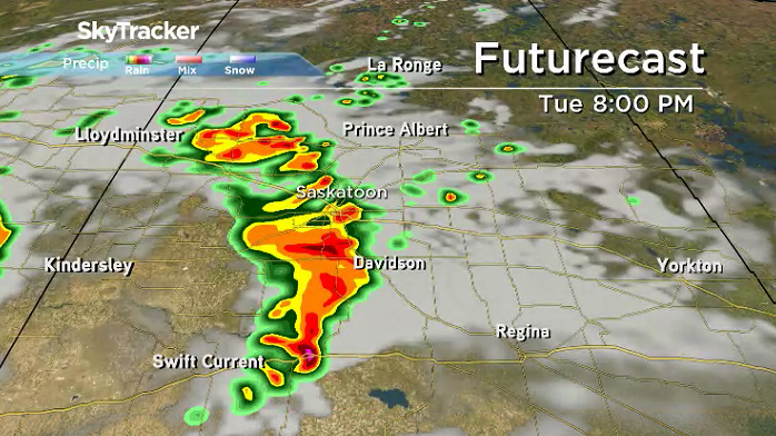
Clouds roll right in later in the afternoon before severe storms press in during the evening after we hit a daytime high in the low 30s with humidex values making it feel like the mid 30s.
Tuesday Night
Thunderstorms that could be severe with strong wind, heavy rain and hail are expected to roll into Saskatoon during the mid-evening.
A few showers and thunderstorms may linger into the overnight period as we cool back into the mid-teens.
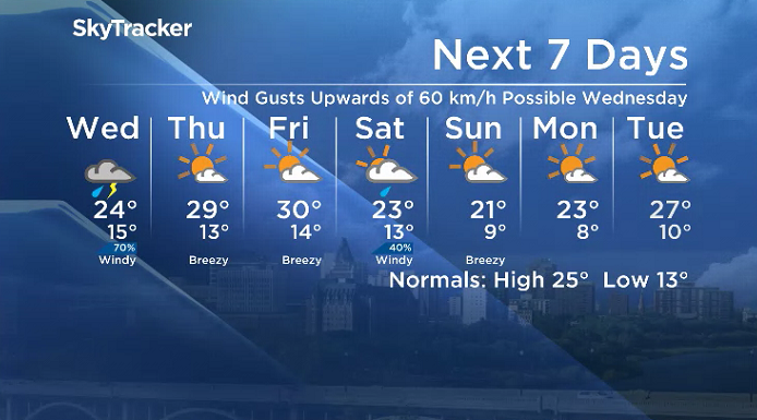
Wednesday
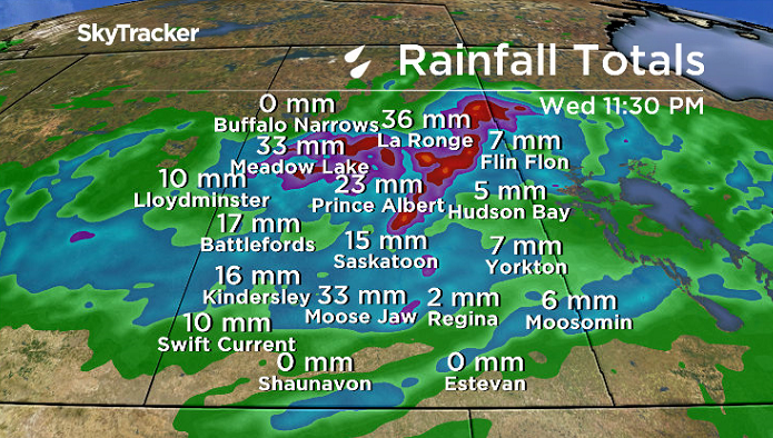
Showers and thunderstorms will continue to rumble through the region from morning right into the afternoon on Wednesday as a low pressure system swings through Saskatchewan.

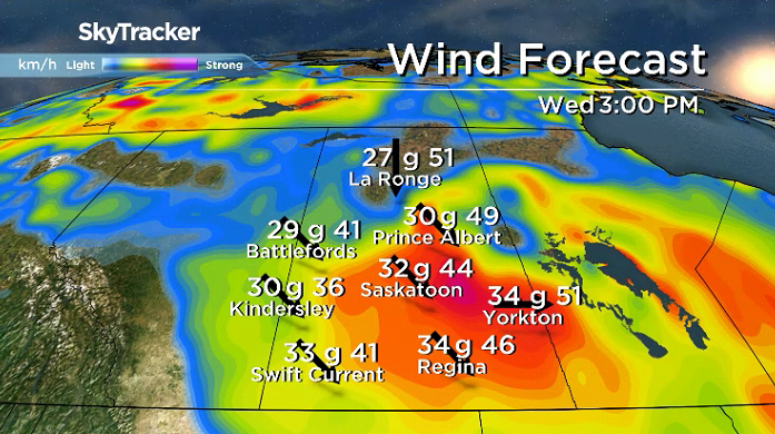
Some areas could see half a month’s worth of rain in one day with this system, which will bring in strong winds gusting upwards of 60 km/h at times and keep temperatures in the mid 20s during the day.
Thursday-Friday
Blue skies and sunshine will be back on Thursday with a few more clouds possible to round off the work week on Friday.
Daytime highs will also rebound, recovering into the upper 20s on Thursday and low 30s to finish off the week on Friday.

Weekend Outlook
A cold front is expected to surge in on Saturday, which will drop daytime highs back into the mid-20s and bring in breezy northerly winds with a good chance of rain.
Sunday will be a bit sunnier, but also a bit cooler with temperatures only making it into the low 20s for an afternoon high.
Gloria Katsiris took the July 10 Your Saskatchewan photo at Jackfish Lake:

Saskatoon weather outlook is your source for Saskatoon’s most accurate forecast and is your one stop shop for all things weather for central and northern Saskatchewan with comprehensive, in depth analysis that you can only find here.
Comments
Want to discuss? Please read our Commenting Policy first.