

A cold front will take its toll on temperatures ahead in the forecast.

Severe Thunderstorm Watch
Environment Canada has issued a severe thunderstorm watch for extreme eastern and parts of north-central Saskatchewan, including the Yorkton, La Ronge and Hudson Bay areas.
Warm and moist conditions in the area coupled with cold front moving through Tuesday afternoon will bring scattered thunderstorms that may continue into the evening, some of which may become severe.
This comes after the cold front brought severe thunderstorms to parts of western Saskatchewan overnight Monday.
For the latest weather alerts download the Global News SkyTracker Weather App for iPhone, iPad or Android.

Get daily National news
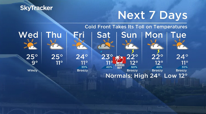
Saskatoon Forecast
Tuesday
Blustery winds kicked in behind a cold front that swept through early Tuesday morning, gusting upwards of 50 km/h to start the day with temperatures dipping back into the teens.
The second last day of school started out under mostly cloudy skies, but quickly started to clear out to bring in some sunny breaks by mid-morning as we warmed back into the low 20s before noon.
Breezy winds stick around for the remainder of the day with gusts of 50 to 60 km/h possible as sunshine kicks into full swing and we climb up to an afternoon high in the mid-20s.
Tuesday Night
Mostly clear skies stick around into the evening as winds begin to ease and the mercury slides back down into single digits by a degree.
- Officials urge Calgarians to play it safe on the water this summer
- Cleanup underway after ‘nasty’ Alberta storm topples trees, damages roofs and buildings
- 30% of Canadians say they were hit by extreme weather in last year: poll
- Funnel clouds, landspout tornadoes possible across much of central Alberta


Wednesday
Beautiful sunny skies will return in full force Wednesday with a few clouds building in later in the day.
A breezy wind will also kick in for the afternoon with 40 km/h gusts possible as we pop up to a daytime high in the mid-20s.

Thursday-Friday
Clouds roll back in on Thursday with partly to mostly cloudy skies expected on Friday with a very slight chance of late day showers as a few disturbances slip through.
Daytime highs should manage to make it up into the mid-20s both days with winds easing back quite a bit to make for a stretch of a few pretty pleasant days.

Canada Day Long Weekend Outlook
Get ready for a potentially active, mostly cloudy, unsettled and stormy Canada Day long weekend across Saskatchewan as slightly cooler conditions with afternoon highs in the low-to-mid 20s move in.
Clouds roll in on Saturday with a chance of late day storms followed by an even better chance for Canada Day on Sunday with lingering showers and thunderstorms possible on holiday Monday.
Noreen Matthews took the June 26 Your Saskatchewan photo at Waskesiu Lake:

Saskatoon weather outlook is your source for Saskatoon’s most accurate forecast and is your one stop shop for all things weather for central and northern Saskatchewan with comprehensive, in depth analysis that you can only find here.
Comments
Want to discuss? Please read our Commenting Policy first.