

March was particularly cold and snowy in Calgary. Snowfall for the month was a whopping 41.9 cm.


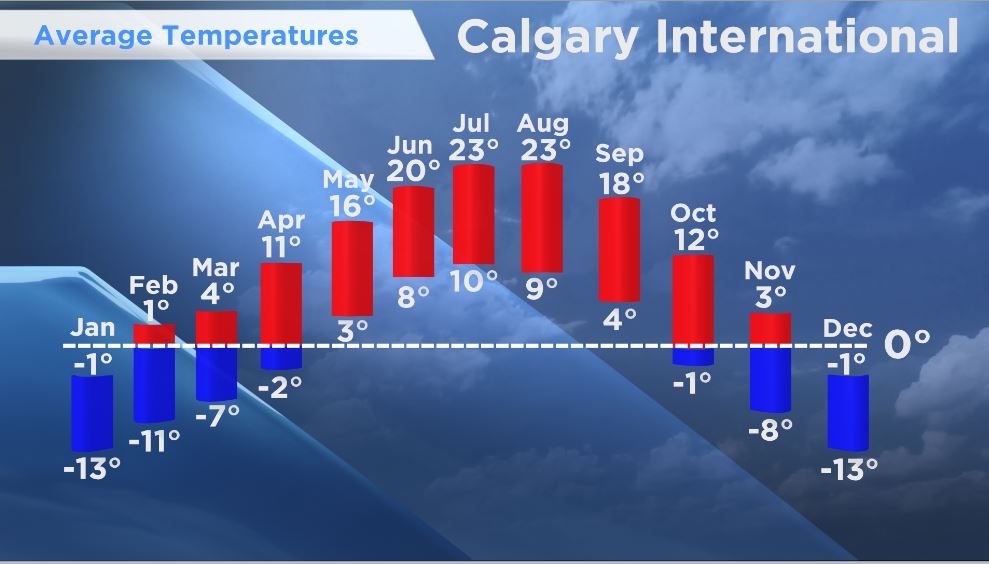
The average high temperature in March was 0.1 C and the average low -10.4 C. The average mean temperature was -5.1 C. Based on records from Environment Canada, we normally see a high of 4.4 C and a low of -7.5 C, with an average mean temperature of –1.6 C. The coldest March on record was in 1899, when the mean temperature was –12.7 C.
So now we’re into April, a month when we look forward to longer days, bright sunshine and warmer temperatures.
We usually get slightly more precipitation in April, with the combined moisture content from rain and snow amounting to an average of 23.9 mm, compared to 17.4 mm in March. In March, 90 per cent of our precipitation falls as snow; in April it’s almost 50/50 rain and snow.

Get breaking National news
We had far more snow than normal this winter season; 106 cm from Dec. 21 to March 20. Most people assume that all that extra snow will be a good source of spring moisture, but the truth is, most of the snow will be gone before the ground thaws.
Some of the snow crystals will sublimate directly into water vapour, without going through the liquid state, and be carried away by wind. Any of the snow that melts and isn’t lost to evaporation or runoff may soak into the ground, but likely with minimal benefit.


What we really need is soaking rains once the ground has thawed — and that usually happens in May and June.
With La Niña — the cold cycle of the El Niño Southern Oscillation (ENSO) — now waning, and a return to neutral conditions expected by the beginning of summer, we will likely continue to see colder than average temperatures through the remainder of spring and a return to average conditions in June. The expectation is that the neutral ENSO cycle will be present through summer and fall, resulting in average temperatures and precipitation.
We received 12 hours and 53 minutes of daylight on the last day of March, but the daylight hours continue to increase in length through April. By the end of the month, we’ll be receiving 14 hours, 44 minutes of daylight.
We average 220.1 hours of bright sunshine in April, which is 53.1 per cent of available sunshine hours. And the average number of days with at least some bright sunshine is 28.
With the sun getting stronger every day, it’s time to start paying attention to the UV forecast and use sunscreen, especially for those still participating in winter sports. Because of the thinner air at higher altitudes and the extra UV reflected off snow, sunburns are more likely in the mountains right now. So slap on the sunblock and don’t forget to wear sunglasses that block UV rays to protect your eyes. Polarized sunglasses go a step further by reducing glare.
Want your weather on the go? Download Global News’ Skytracker weather app for IOS and Android.
Comments
Want to discuss? Please read our Commenting Policy first.