

Mist and mild air continue before snow and a big cool down kick in.

Saskatoon Forecast
Wednesday
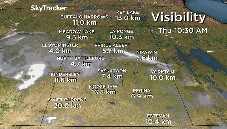
It was the fourth misty morning in a row in Saskatoon with visibility reduced at times Tuesday evening to a few hundred metres at times before improving into Wednesday with a few pockets of light snow overnight.
It felt like the mid-minus teens with wind chill to start the day as temperatures sat around -7 degrees right into the noon hour in the mist.
Cloudy skies will stick around for the rest of the day with mist and a chance of flurries throughout the day as we warm up to a daytime high in mid-minus single digits.

Get breaking National news
Wednesday Night
Mostly cloudy skies will stick around through the night with a good chance of mist thickening up to bring in some thicker fog reducing visibility significantly at times as we cool down toward minus double digits.
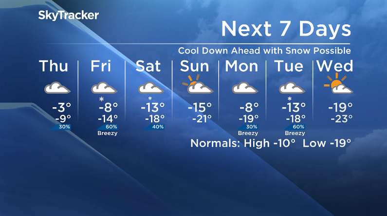
Thursday
It’ll feel like mid-minus teens to start the day with wind chill with some mist possible in the morning before we warm right up during the day to an afternoon high just shy of the freezing mark.
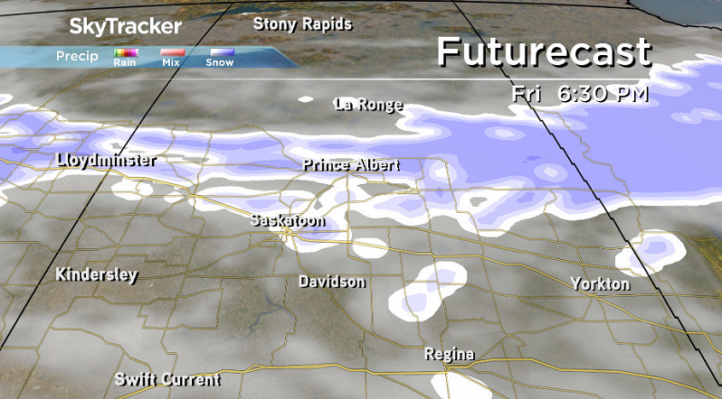
A system will slide in from Alberta during the day that’ll keep us in the clouds with a slight chance of flurries during the day with a good chance of snow in the evening.
Friday
Some models are indicating a good chance of an accumulating snowfall in Saskatoon on Friday behind the system if the upper level front known as a TROWAL, TRough Of Warm Air aLoft, swings through.
There is a chance that we may only see minimal precipitation though, so we will keep an eye on the situation and have a much better idea midday Thursday, but what is likely is cloudy skies and temperatures cooling into minus double digits during the day.


Weekend Outlook
There could be some lingering snow early Saturday with mostly cloudy skies sticking around through the weekend as daytime highs dip back into minus double digits and morning lows drop toward the -20s.

Hank Vlietstra took the Jan. 24 Your Saskatchewan photo on the Battle River:

READ MORE: Get a 2018 Your Saskatchewan Calendar today
Saskatoon weather outlook is your source for Saskatoon’s most accurate forecast and is your one stop shop for all things weather for central and northern Saskatchewan with comprehensive, in depth analysis that you can only find here.
Comments
Want to discuss? Please read our Commenting Policy first.