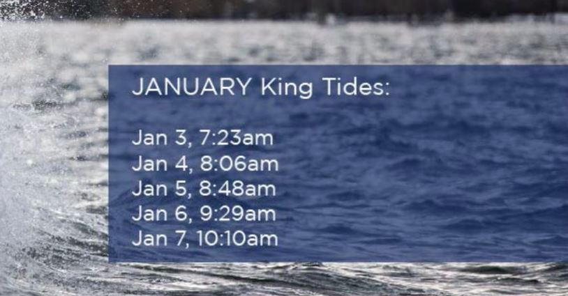
The phenomenon known as “King Tide” has returned to Metro Vancouver, and it’s creating quite the stir on social media.

The unusually high tides, forecast for a period between Jan. 3 and Jan. 7, have already caused minor flooding in some low lying areas of the region.
King Tides, also known as perigean spring tides, refer to the highest tidal ranges of a year.
They occur when the sun and moon’s gravitational forces reinforce each other when the moon is closest to the earth, and tend to be more pronounced in the winter.
WATCH: King Tide sparks state of emergency in Delta (2014)
During a King Tide, water levels can reach as high as five metres in elevation, and can cause more pronounced flooding if they combine with a storm surge.
The City of Vancouver has asked residents to snap photos of the high tide event and submit them as a part of a program to plan ahead for rising sea levels due to climate change.
Metro Vancouver residents have taken up the challenge, and have been sharing dramatic images across social media.
Here’s a look at how the King Tide appeared across the region, through your eyes.
Vancouver
https://www.instagram.com/p/BdnbSg2A-iW/?tagged=kingtide

Get daily National news
https://www.instagram.com/p/BdnmB-OFsrY/?tagged=kingtide
https://www.instagram.com/p/Bdnk53tH7oz/?tagged=kingtide
https://www.instagram.com/p/BdnjSHHAHQX/?tagged=kingtide
North Vancouver
Surrey
https://www.instagram.com/p/BdnN6vKAP7e/?tagged=kingtide
Richmond
Port Moody
https://www.instagram.com/p/BdnolwbHRzQ/?tagged=kingtide
https://www.instagram.com/p/BdnsDsqBMfk/?tagged=kingtide
https://www.instagram.com/p/Bdn7CYwFc4N/?tagged=kingtide


Comments