

UPDATE: Wind warning issued for southern and central Saskatchewan

Destructive warning level wind gusts upwards of 100 km/h move into Saskatoon.
Special Weather Statement
Environment Canada has issued a special weather statement for Saskatoon and all of central and southern Saskatchewan for strong, gusty winds expected Tuesday and Wednesday.
An intense low pressure system is forecast to track through the eastern Prairies over the next few days with winds gusts up to and possibly exceeding 90 km/h expected to develop Tuesday afternoon.
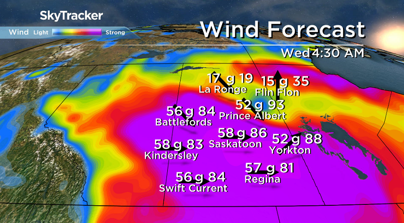
Gusts of 90 km/h will expand east to affect the rest of southern Saskatchewan overnight Tuesday with the passage of the cold front before slowly weakening Wednesday afternoon.
The agency says damage to buildings, such as roof shingles and windows, may occur and high winds may toss loose objects or cause tree branches to break.
Wind warnings are likely to be issued for parts of southern Saskatchewan.
For weather on the go download the Global News Skytracker weather app for iPhone, iPad or Android.
Saskatoon Forecast
Today
After a chilly start to the weekend with temperatures diving back to -9 Saturday morning, the coldest we’ve been in over seven months, we managed to recover into high single digits later in the day and up into double digits Sunday.
-5 is what it felt like Monday morning in Saskatoon with wind chill as temperatures dipped back to the freezing mark.

Get daily National news
Partly cloudy skies started the day and a breezy westerly wind kicked in around 20 to 30 km/h, which helped quickly warm us up with leaps and bounds of 4 to 6 degrees at a time.
After rising up into the mid teens by noon, we continue our climb through the afternoon with a daytime high in the mid-to-upper teens under partly to mostly sunny skies.
Tonight
Partly cloudy skies will stick around through the evening before mostly clear skies move in overnight as we dip back into low single digits overnight.
Tuesday


A system will swing into Alberta on Tuesday with a kick of warm air out ahead of it that’ll pick up southwesterly winds to 35 km/h with gusts upwards of 60 km/h in the afternoon.
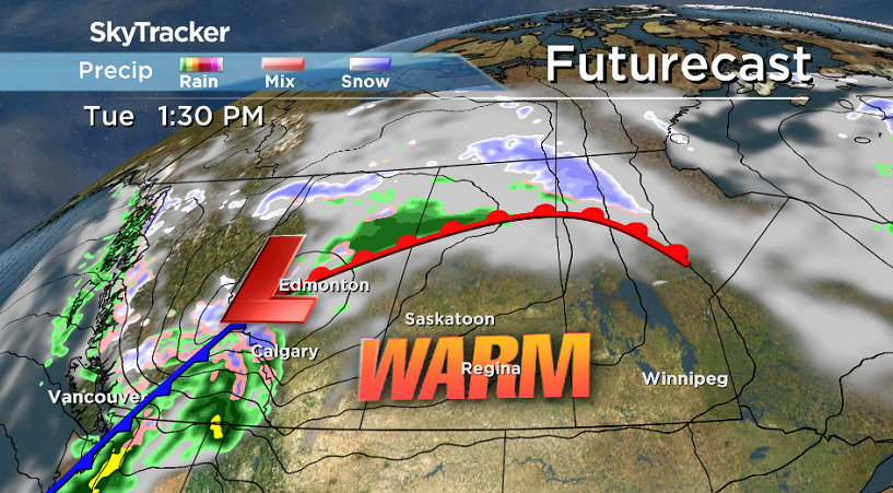
Mostly sunny skies will start off the day with some clouds with that system building in late in the day as we rise up to toasty a daytime high around 20 degrees.

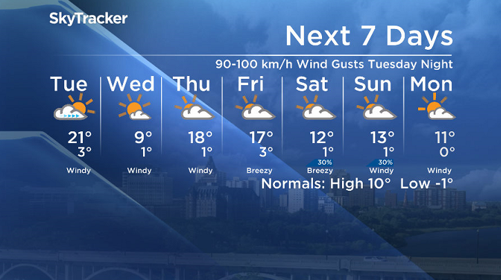
Warning level, potentially damaging winds around 60 to 70 km/h with gusts potentially up to 90 to 100 km/h will kick in Tuesday night as the cold front associated with the system slides through.
Be sure to bring in or baton down anything that may be damaged by extremely strong wind gusts that will blast through the region into Wednesday morning along with a risk of some rain.
Wednesday-Friday
After a wild and windy start to the day on Wednesday, calmer conditions will move in for the afternoon as cooler air settles in with a daytime high just shy of double digits under mostly sunny skies.
Warmer air will return to end off the work week as a short-lived upper ridge builds back in, boosting daytime highs back into the mid-to-upper teens under partly to mostly cloudy skies.

Weekend Outlook
It looks like partly to mostly cloudy skies will stick around for the weekend with daytime highs dropping back into low double digits as an upper trough swings back in.
The Oct. 16 Your Saskatchewan photo was taken by Sara Gardiner at Île-à-la-Crosse:

Saskatoon weather outlook is your source for Saskatoon’s most accurate forecast and is your one stop shop for all things weather for central and northern Saskatchewan with comprehensive, in depth analysis that you can only find here.
Comments
Want to discuss? Please read our Commenting Policy first.